IMAGES TAKEN NEAR TO
Whincover Road, LEEDS, LS12 5JR
Introduction
This page details the photographs taken nearby to Whincover Road, LS12 5JR by members of the Geograph project.
The Geograph project started in 2005 with the aim of publishing, organising and preserving representative images for every square kilometre of Great Britain, Ireland and the Isle of Man.

There are currently over 7.5m images from over14,400 individuals and you can help contribute to the project by visiting https://www.geograph.org.uk
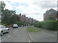
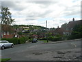
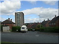
Image Map
Images are licensed for reuse under creativecommons.org/licenses/by-sa/2.0
Notes
- Clicking on the map will re-center to the selected point.
- The higher the marker number, the further away the image location is from the centre of the postcode.
Image Listing (104 Images Found)
Images are licensed for reuse under creativecommons.org/licenses/by-sa/2.0
Image
Details
Distance
1
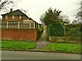
Path from Whincover Bank to Whincover Grove
A short urban footpath.
Image: © Stephen Craven
Taken: 29 Nov 2020
0.03 miles
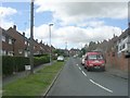
3
Whincover Bank - viewed from Whincover Road
Image: © Betty Longbottom
Taken: 9 Aug 2011
0.04 miles
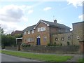
4
St Wilfrid's Presbytery, Farnley
The priest's house is connected to the church vestry by a covered corridor.
Image: © Stephen Craven
Taken: 29 Nov 2020
0.04 miles
5
Cow Close Road - viewed frtom Whincover Road
Image: © Betty Longbottom
Taken: 9 Aug 2011
0.05 miles
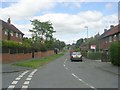
6
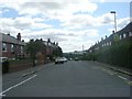
Whincover Road - viewed from Wincover View
Image: © Betty Longbottom
Taken: 9 Aug 2011
0.05 miles
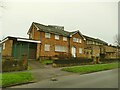
7
St Wilfrid's Vicarage - Whincover Bank
Image: © Betty Longbottom
Taken: 9 Aug 2011
0.05 miles
10
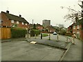
Traffic barrier at the end of Cow Close Road
The original alignment of Cow Close Road north-west from this point has disappeared under housing, but the road abuts the later alignment of Whincover Bank (part of a mid-20th century housing estate) with a slight dog-leg. Motor vehicles can't get through from one housing area to the other, perhaps to stop traffic from the ring road using it as a rat-run. Note the unofficial timber ramp, probably placed by local skateboarders.
Image: © Stephen Craven
Taken: 29 Nov 2020
0.05 miles