IMAGES TAKEN NEAR TO
Tong Road, LEEDS, LS12 5EW
Introduction
This page details the photographs taken nearby to Tong Road, LS12 5EW by members of the Geograph project.
The Geograph project started in 2005 with the aim of publishing, organising and preserving representative images for every square kilometre of Great Britain, Ireland and the Isle of Man.

There are currently over 7.5m images from over14,400 individuals and you can help contribute to the project by visiting https://www.geograph.org.uk
Image Map
Images are licensed for reuse under creativecommons.org/licenses/by-sa/2.0
Notes
- Clicking on the map will re-center to the selected point.
- The higher the marker number, the further away the image location is from the centre of the postcode.
Image Listing (46 Images Found)
Images are licensed for reuse under creativecommons.org/licenses/by-sa/2.0
Image
Details
Distance
1
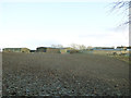
Beulah Farm
Viewed from the top of Post Hill woods.
Image: © Stephen Craven
Taken: 6 Jan 2018
0.02 miles
2
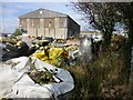
Beulah Farm Trig Point
I spotted this trig as I drove past then parked in the pub car park before going back for a closer look. Beulah Farm yard is not the tidiest in Yorkshire.
Image: © Rude Health
Taken: 5 Oct 2014
0.05 miles
3
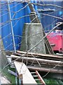
Triangulation pillar at Beulah Farm, off Tong Road
Not much use at present.
Image: © Humphrey Bolton
Taken: 30 Mar 2010
0.06 miles
4
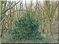
Holly tree in Post Hill woods
The woods are almost entirely deciduous; this holly was an exception.
Image: © Stephen Craven
Taken: 6 Jan 2018
0.07 miles
5
Paddocks at Beulah Grange Farm
I describe this field as paddocks because the wire fences, cone and bathtubs suggest use by horse training.
Image: © Stephen Craven
Taken: 6 Jan 2018
0.08 miles
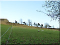
7
Horses at Beulah Farm
Beyond the horses is the corner of Beulah Woods.
Image: © Stephen Craven
Taken: 6 Jan 2018
0.08 miles
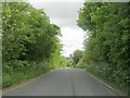
8
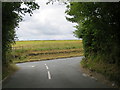
Gamble Lane joining Tong Road near Beulah Farm
Looking south-westward.
Image: © Peter Wood
Taken: 14 Jul 2017
0.09 miles
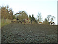
9
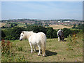
Ponies at Beulah Farm
This shot is taken from the trig point at the top of the Troy Dale valley. In the middle distance is the wooded valley (still in the grid square). Pudsey can be seen in the far distance with the tower of its parish church on the skyline.
Image: © michael ely
Taken: 25 Jul 2006
0.10 miles
10
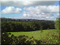
Pastures near Beulah Farm
Woodland along Pudsey Beck in the middle ground, Pudsey town in the background
Image: © Schlosser67
Taken: 2 Oct 2016
0.10 miles