IMAGES TAKEN NEAR TO
Stonecliffe Place, LEEDS, LS12 5BQ
Introduction
This page details the photographs taken nearby to Stonecliffe Place, LS12 5BQ by members of the Geograph project.
The Geograph project started in 2005 with the aim of publishing, organising and preserving representative images for every square kilometre of Great Britain, Ireland and the Isle of Man.

There are currently over 7.5m images from over14,400 individuals and you can help contribute to the project by visiting https://www.geograph.org.uk
Image Map
Images are licensed for reuse under creativecommons.org/licenses/by-sa/2.0
Notes
- Clicking on the map will re-center to the selected point.
- The higher the marker number, the further away the image location is from the centre of the postcode.
Image Listing (103 Images Found)
Images are licensed for reuse under creativecommons.org/licenses/by-sa/2.0
Image
Details
Distance
1
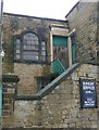
Entrance to the Methodist Sunday School, Farnley
The door into the square building on the right has 1821 on the lintel, whilst the Sunday School door lintel is dated 1828. At the top, painted out, are the words "Wesleyan Methodist".
Image: © Humphrey Bolton
Taken: 30 Mar 2010
0.02 miles
2
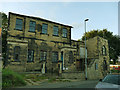
Former Methodist chapel, Stonebridge Lane, Farnley
The former Wesleyan chapel, with Sunday school attached to the right, is closed and currently unoccupied. It dates from 1828, replacing an earlier chapel of 1797. The building is grade II listed (list entry 1255978) and the listing gives a detailed history of alterations. The walls and gates are separately listed (entry 1255985). Reasons for listing include internal features such as a gallery, complete set of box pews, and double deck pulpit. It is to be hoped these are not lost to vandalism or subsequent conversion of the building.
Image: © Stephen Craven
Taken: 9 Sep 2020
0.03 miles
3
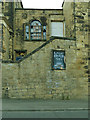
Former Methodist chapel, Stonebridge Lane, Farnley - detail
The former Wesleyan chapel, with Sunday school attached to the right, is closed and currently unoccupied. See Image for context and more information.
Image: © Stephen Craven
Taken: 9 Sep 2020
0.03 miles
5
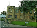
Former Methodist Sunday school, Stonebridge Lane, Farnley
The former Sunday school, currently disused, dates from 1828 but was enlarged and altered in 1921. It is listed grade II along with the attached chapel Image
Image: © Stephen Craven
Taken: 9 Sep 2020
0.03 miles
8
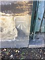
Benchmark on Sunday School NW Side Stonebridge Lane
Benchmark description https://www.bench-marks.org.uk/bm122735
Image: © OfficeOfPudseyBMs
Taken: 29 May 2020
0.04 miles
9
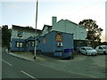
The Nag's Head, Stonebridge Lane, Farnley
See also Image
Image: © Stephen Craven
Taken: 9 Sep 2020
0.04 miles
10
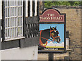
Sign of the Nag's Head, Farnley
For context, see Image
Image: © Stephen Craven
Taken: 18 Oct 2015
0.04 miles