IMAGES TAKEN NEAR TO
Stonecliffe Close, LEEDS, LS12 5BJ
Introduction
This page details the photographs taken nearby to Stonecliffe Close, LS12 5BJ by members of the Geograph project.
The Geograph project started in 2005 with the aim of publishing, organising and preserving representative images for every square kilometre of Great Britain, Ireland and the Isle of Man.

There are currently over 7.5m images from over14,400 individuals and you can help contribute to the project by visiting https://www.geograph.org.uk
Image Map
Images are licensed for reuse under creativecommons.org/licenses/by-sa/2.0
Notes
- Clicking on the map will re-center to the selected point.
- The higher the marker number, the further away the image location is from the centre of the postcode.
Image Listing (105 Images Found)
Images are licensed for reuse under creativecommons.org/licenses/by-sa/2.0
Image
Details
Distance
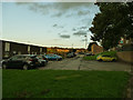
1
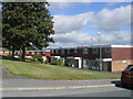
Stonecliffe Close - Stonecliffe Crescent
Image: © Betty Longbottom
Taken: 9 Aug 2011
0.03 miles
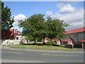
2
Farnley Hill Methodist Church - Stonebridge Lane
Image: © Betty Longbottom
Taken: 17 May 2011
0.03 miles
3
Stonecliffe Crescent - off Stonecliffe Garth
Image: © Betty Longbottom
Taken: 9 Aug 2011
0.04 miles
4
Stonecliffe Garth - Stonebridge Lane
Image: © Betty Longbottom
Taken: 9 Aug 2011
0.04 miles
5
Stonecliffe Lawn - Stonebridge Lane
Image: © Betty Longbottom
Taken: 9 Aug 2011
0.05 miles
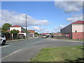
6
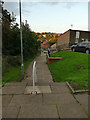
Steps parallel to Stonebridge Lane
For pedestrians, an alternative to walking up the steep Stonebridge Lane is to use these steps that connect the various levels of a housing estate on the hillside.
Image: © Stephen Craven
Taken: 9 Sep 2020
0.06 miles
7
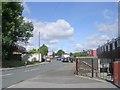
Stonecliffe Mount - Stonebridge Lane
Image: © Betty Longbottom
Taken: 9 Aug 2011
0.06 miles
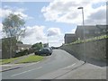
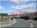
9
Bawn Drive, Farnley
This housing estate is built on a steep hillside with roads running horizontally.
Image: © Stephen Craven
Taken: 9 Sep 2020
0.07 miles
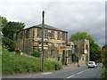
10
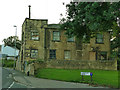
Former Methodist Sunday school, Stonebridge Lane, Farnley
The former Sunday school, currently disused, dates from 1828 but was enlarged and altered in 1921. It is listed grade II along with the attached chapel Image
Image: © Stephen Craven
Taken: 9 Sep 2020
0.07 miles