IMAGES TAKEN NEAR TO
Cross Lane, LEEDS, LS12 5AA
Introduction
This page details the photographs taken nearby to Cross Lane, LS12 5AA by members of the Geograph project.
The Geograph project started in 2005 with the aim of publishing, organising and preserving representative images for every square kilometre of Great Britain, Ireland and the Isle of Man.

There are currently over 7.5m images from over14,400 individuals and you can help contribute to the project by visiting https://www.geograph.org.uk
Image Map
Images are licensed for reuse under creativecommons.org/licenses/by-sa/2.0
Notes
- Clicking on the map will re-center to the selected point.
- The higher the marker number, the further away the image location is from the centre of the postcode.
Image Listing (90 Images Found)
Images are licensed for reuse under creativecommons.org/licenses/by-sa/2.0
Image
Details
Distance

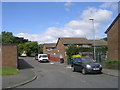
4
Cross Lane - viewed from Hall Lane
Image: © Betty Longbottom
Taken: 17 May 2011
0.04 miles
5
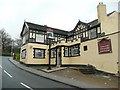
The Nag's Head, Stonebridge Lane, Farnley
Near the top of a steep hill - the nag would have been in need of a rest.
Image: © Humphrey Bolton
Taken: 30 Mar 2010
0.05 miles
6
Butterbowl Garth - Butterbowl Drive
Image: © Betty Longbottom
Taken: 9 Aug 2011
0.05 miles
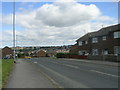
7
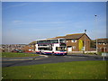
Climbing out of the Butterbowl
A bus reaches the top of Butterbowl Drive as it approaches Whincover Drive terminus, Old Farnley. The housing visible in the distance is, I think, part of Armley.
Image: © Richard Vince
Taken: 1 Oct 2011
0.06 miles
8
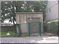
Electricity Substation No 2632 - Whincover Drive West
Image: © Betty Longbottom
Taken: 9 Aug 2011
0.06 miles
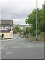
10
Butterbowl Drive - viewed from Bawn Approach
Image: © Betty Longbottom
Taken: 9 Aug 2011
0.06 miles