IMAGES TAKEN NEAR TO
Fawcett Gardens, LEEDS, LS12 4TS
Introduction
This page details the photographs taken nearby to Fawcett Gardens, LS12 4TS by members of the Geograph project.
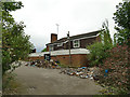
The Geograph project started in 2005 with the aim of publishing, organising and preserving representative images for every square kilometre of Great Britain, Ireland and the Isle of Man.

There are currently over 7.5m images from over14,400 individuals and you can help contribute to the project by visiting https://www.geograph.org.uk
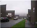
Image Map
Images are licensed for reuse under creativecommons.org/licenses/by-sa/2.0
Notes
- Clicking on the map will re-center to the selected point.
- The higher the marker number, the further away the image location is from the centre of the postcode.
Image Listing (167 Images Found)
Images are licensed for reuse under creativecommons.org/licenses/by-sa/2.0
Image
Details
Distance
1
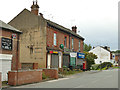
Shops on Lower Wortley Road
The shops are boarded up but that may just be a security measure due to temporary closure in the Covid-19 pandemic. There is a postbox on the corner.
Image: © Stephen Craven
Taken: 19 Jun 2020
0.02 miles
2
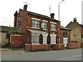
The William IV, Lower Wortley Road
The pub was boarded up but that may just be a security measure due to temporary closure in the Covid-19 pandemic. According to CAMRA it was still open in 2018.
Image: © Stephen Craven
Taken: 19 Jun 2020
0.03 miles
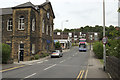
3
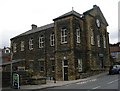
Lower Wortley Methodist Church - Branch Road
Built 1884 as a United Methodist Free Church.
Image: © Betty Longbottom
Taken: 2 Oct 2007
0.04 miles
4
The former Horse and Groom, Lower Wortley Road
The pub was built in the 1960s, replacing an earlier pub of the same name on a different site. It was reached up a long ramp from the road, although it could also be reached directly from the housing estate behind. It was still open in 1993 when described in a CAMRA guide to Leeds pubs as a modern two-roomed Tetley pub, but looks to have been closed for several years now.
Image: © Stephen Craven
Taken: 19 Jun 2020
0.05 miles
5
Rear of the former Horse and Groom, Lower Wortley Road
The pub was built in the 1960s, replacing an earlier pub of the same name on a different site. It was reached up a long ramp from the road, although it could also be reached directly from the housing estate behind. It looks to have been closed for several years.
Image: © Stephen Craven
Taken: 19 Jun 2020
0.05 miles
7
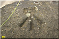
Rivet Bench Mark, Branch Road Church
Bench Mark Database: http://www.bench-marks.org.uk/bm85454
Image: © Mark Anderson
Taken: 14 Jun 2017
0.06 miles
8
Branch Road
There is a rivet bench mark on the wall in front of the church and a closer view can be seen here: Image
Image: © Mark Anderson
Taken: 14 Jun 2017
0.06 miles
9
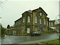
Lower Wortley Methodist Church, Branch Road
Built in 1884 as a United Methodist Free Church and still in use as such.
Image: © Stephen Craven
Taken: 29 Nov 2020
0.06 miles
10
Sign for the former Horse and Groom, Lower Wortley Road
The pub was built in the 1960s, replacing an earlier pub of the same name on a different site. It was reached up a long ramp from the road, although it could also be reached directly from the housing estate behind. It looks to have been closed for several years and the sign is fading away.
Image: © Stephen Craven
Taken: 19 Jun 2020
0.06 miles