IMAGES TAKEN NEAR TO
Lower Wortley Road, LS12 4PT
Introduction
This page details the photographs taken nearby to Lower Wortley Road, LS12 4PT by members of the Geograph project.
The Geograph project started in 2005 with the aim of publishing, organising and preserving representative images for every square kilometre of Great Britain, Ireland and the Isle of Man.

There are currently over 7.5m images from over14,400 individuals and you can help contribute to the project by visiting https://www.geograph.org.uk
Image Map
Images are licensed for reuse under creativecommons.org/licenses/by-sa/2.0
Notes
- Clicking on the map will re-center to the selected point.
- The higher the marker number, the further away the image location is from the centre of the postcode.
Image Listing (119 Images Found)
Images are licensed for reuse under creativecommons.org/licenses/by-sa/2.0
Image
Details
Distance
1
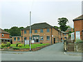
Westfield Business Park, Lower Wortley Road
Comprising two buildings, one of them fronting the main road and one behind.
Image: © Stephen Craven
Taken: 19 Jun 2020
0.01 miles
3
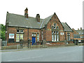
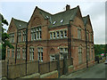
Lower Wortley Community Centre - Lower Wortley Road
Originally a Leeds School Board school built 1876 and extended 1884, now listed grade II (list entry 1375112) and used as a community centre.
Image: © Stephen Craven
Taken: 19 Jun 2020
0.05 miles
5
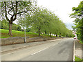
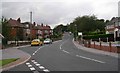
Fawcett Lane, Lower Wortley
To the left is Western Flatts Cliff Park.
Image: © Stephen Craven
Taken: 19 Jun 2020
0.07 miles
6
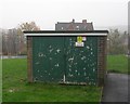
Electricity Substation No 3780 - Fawcett Way
Image: © Betty Longbottom
Taken: 8 Nov 2011
0.08 miles
7
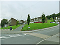
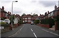
Bottom of Fawcett Way, Lower Wortley
This area was redeveloped in the 1960s. The original Horse and Groom pub stood roughly on the site of the path across the grass in this view.
Image: © Stephen Craven
Taken: 19 Jun 2020
0.08 miles
9
Forster Mews, Lower Wortley Road (rear)
Originally a Leeds School Board school built 1884, architect Richard Adams, to supplement the earlier school nearby Image, now listed grade II (list entry 1375113) and converted to apartments. The school has moved to new premises immediately to the west. See also Image
Image: © Stephen Craven
Taken: 19 Jun 2020
0.08 miles
10
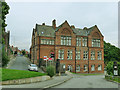
Forster Mews, Lower Wortley Road (front)
Originally a Leeds School Board school built 1884, architect Richard Adams, to supplement the earlier school nearby Image, now listed grade II (list entry 1375113) and converted to apartments. The school has moved to new premises immediately to the west. See also Image and Image
Image: © Stephen Craven
Taken: 19 Jun 2020
0.08 miles