IMAGES TAKEN NEAR TO
Fawcett Avenue, LEEDS, LS12 4PR
Introduction
This page details the photographs taken nearby to Fawcett Avenue, LS12 4PR by members of the Geograph project.
The Geograph project started in 2005 with the aim of publishing, organising and preserving representative images for every square kilometre of Great Britain, Ireland and the Isle of Man.

There are currently over 7.5m images from over14,400 individuals and you can help contribute to the project by visiting https://www.geograph.org.uk
Image Map
Images are licensed for reuse under creativecommons.org/licenses/by-sa/2.0
Notes
- Clicking on the map will re-center to the selected point.
- The higher the marker number, the further away the image location is from the centre of the postcode.
Image Listing (113 Images Found)
Images are licensed for reuse under creativecommons.org/licenses/by-sa/2.0
Image
Details
Distance
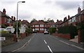
3
Shops on Lower Wortley Road
Comprising an estate agent, hair salon and catering business.
Image: © Stephen Craven
Taken: 19 Jun 2020
0.04 miles
4
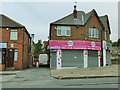
Archers Sweets and Tonic Barbers, Lower Wortley Road
The dedicated sweet shop is a rare sight these days.
Image: © Stephen Craven
Taken: 19 Jun 2020
0.05 miles
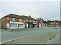
5
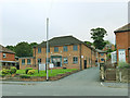
Westfield Business Park, Lower Wortley Road
Comprising two buildings, one of them fronting the main road and one behind.
Image: © Stephen Craven
Taken: 19 Jun 2020
0.05 miles
6
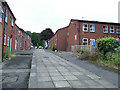
Fawcett Lane, Lower Wortley
To the left is Western Flatts Cliff Park.
Image: © Stephen Craven
Taken: 19 Jun 2020
0.08 miles
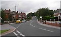
7
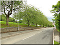
Pedestrianised section of Western Road
Despite this being quite a wide space between the houses, and traffic free, the Council has unfortunately put up 'no cycling' signs.
Image: © Stephen Craven
Taken: 19 Jun 2020
0.08 miles
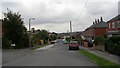
8
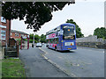
Bus stop on Lower Wortley Road
The 42 bus was passing without anyone getting on or off. But this was during the Covid-19 pandemic, with bus travel being restricted to small numbers of people making 'essential' journeys.
Image: © Stephen Craven
Taken: 19 Jun 2020
0.09 miles
10
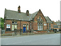
Lower Wortley Community Centre - Lower Wortley Road
Originally a Leeds School Board school built 1876 and extended 1884, now listed grade II (list entry 1375112) and used as a community centre.
Image: © Stephen Craven
Taken: 19 Jun 2020
0.09 miles