IMAGES TAKEN NEAR TO
Blue Hill Crescent, LEEDS, LS12 4PA
Introduction
This page details the photographs taken nearby to Blue Hill Crescent, LS12 4PA by members of the Geograph project.
The Geograph project started in 2005 with the aim of publishing, organising and preserving representative images for every square kilometre of Great Britain, Ireland and the Isle of Man.

There are currently over 7.5m images from over14,400 individuals and you can help contribute to the project by visiting https://www.geograph.org.uk
Image Map
Images are licensed for reuse under creativecommons.org/licenses/by-sa/2.0
Notes
- Clicking on the map will re-center to the selected point.
- The higher the marker number, the further away the image location is from the centre of the postcode.
Image Listing (67 Images Found)
Images are licensed for reuse under creativecommons.org/licenses/by-sa/2.0
Image
Details
Distance
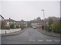
3
Cliffe Park Crescent - Blue Hill Lane
Image: © Betty Longbottom
Taken: 8 Nov 2011
0.05 miles
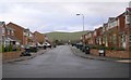
4
Cliffe Park Mount - Cliffe Park Crescent
Image: © Betty Longbottom
Taken: 8 Nov 2011
0.09 miles
5
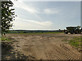
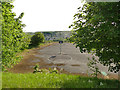
Preparing the pitch
According to one of the workmen here, several five-a-side football pitches were being constructed here.
Image: © Stephen Craven
Taken: 21 May 2020
0.09 miles
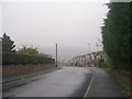
6
Torque, Wortley Moor Road
Viewed from Cabbage Hill. According to its website, Torque is a logistics company with local origins, founded in Bramley in 1991, but now operating nationwide.
Image: © Stephen Craven
Taken: 17 Jan 2021
0.10 miles
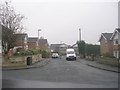
7
Cliffe Park Crescent - Blue Hill Lane
Image: © Betty Longbottom
Taken: 8 Nov 2011
0.11 miles
8
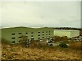
The top of Cabbage Hill
Cabbage Hill is now a public open space on high ground above Wortley, but this western end of the site is landfill to a former quarry, while the eastern end is an infilled claypit for the former Wortley brickworks. The area in the centre of this view is probably a 'greenfield' site without former industrial use, although former agricultural use may have given the site its name.
Image: © Stephen Craven
Taken: 17 Jan 2021
0.12 miles
9
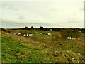
Playground of the former Wortley High School
According to Wikipedia, Wortley High School opened in 1992, in 2009 becoming part of Swallow Hill Community College, but closing only a couple of years later and most of the buildings demolished in 2013. A few of the sports pitches remain.
Image: © Stephen Craven
Taken: 21 May 2020
0.13 miles
10
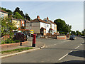
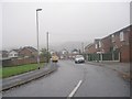
Postbox on Blue Hill Lane
On the corner of Blue Hill Crescent.
Image: © Stephen Craven
Taken: 21 May 2020
0.13 miles