IMAGES TAKEN NEAR TO
Blue Hill Lane, LEEDS, LS12 4NZ
Introduction
This page details the photographs taken nearby to Blue Hill Lane, LS12 4NZ by members of the Geograph project.
The Geograph project started in 2005 with the aim of publishing, organising and preserving representative images for every square kilometre of Great Britain, Ireland and the Isle of Man.

There are currently over 7.5m images from over14,400 individuals and you can help contribute to the project by visiting https://www.geograph.org.uk
Image Map
Images are licensed for reuse under creativecommons.org/licenses/by-sa/2.0
Notes
- Clicking on the map will re-center to the selected point.
- The higher the marker number, the further away the image location is from the centre of the postcode.
Image Listing (90 Images Found)
Images are licensed for reuse under creativecommons.org/licenses/by-sa/2.0
Image
Details
Distance
1
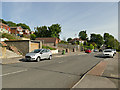
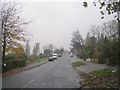
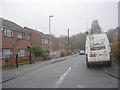
Blue Hill Lane
Round the bend in the distance it becomes Fawcett Lane.
Image: © Stephen Craven
Taken: 21 May 2020
0.02 miles
4
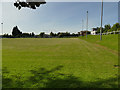
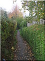
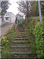
Steps up from Blue Hill Lane
The path leads to Western Flatts Cliff Park.
Image: © Stephen Craven
Taken: 21 May 2020
0.05 miles
5
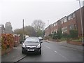
Blue Hill Lane - viewed from Fawcett Lane
Image: © Betty Longbottom
Taken: 8 Nov 2011
0.05 miles
6
Wheelwright Close - Wheelwright Avenue
Image: © Betty Longbottom
Taken: 8 Nov 2011
0.06 miles
7
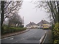
Fawcett Lane - viewed from Blue Hill Lane
Image: © Betty Longbottom
Taken: 8 Nov 2011
0.06 miles
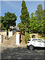
8
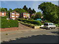
Houses on Blue Hill Lane
The houses here are curiously set back a long way from the road, resulting in long, steep driveways.
Image: © Stephen Craven
Taken: 21 May 2020
0.07 miles
9
Wheelwright Close - Wheelwright Avenue
Image: © Betty Longbottom
Taken: 8 Nov 2011
0.08 miles