IMAGES TAKEN NEAR TO
Leysholme Terrace, LEEDS, LS12 4HL
Introduction
This page details the photographs taken nearby to Leysholme Terrace, LS12 4HL by members of the Geograph project.
The Geograph project started in 2005 with the aim of publishing, organising and preserving representative images for every square kilometre of Great Britain, Ireland and the Isle of Man.

There are currently over 7.5m images from over14,400 individuals and you can help contribute to the project by visiting https://www.geograph.org.uk
Image Map
Images are licensed for reuse under creativecommons.org/licenses/by-sa/2.0
Notes
- Clicking on the map will re-center to the selected point.
- The higher the marker number, the further away the image location is from the centre of the postcode.
Image Listing (86 Images Found)
Images are licensed for reuse under creativecommons.org/licenses/by-sa/2.0
Image
Details
Distance
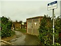
1
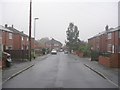
Leysholme Terrace - looking towards Leysholme Crescent
Image: © Betty Longbottom
Taken: 8 Nov 2011
0.01 miles
2
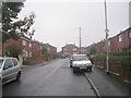
Leysholme Terrace - Leysholme Crescent
Image: © Betty Longbottom
Taken: 8 Nov 2011
0.04 miles
3
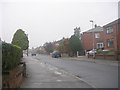
Leysholme Crescent - Leysholme Drive
Image: © Betty Longbottom
Taken: 8 Nov 2011
0.04 miles
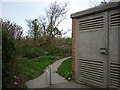
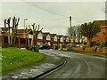
5
Southern entrance to Cabbage Hill open space
Cabbage Hill is now a public open space on high ground above Wortley, but the eastern end of the site, at least, is landfill to a former claypit for the former Wortley brickworks. This is the entrance from Leysholme Crescent. Assuming the substation hasn't moved, the path has been realigned since 2011, see Image The name apparently derives from the fact that cabbages were grown here at one time.
Image: © Stephen Craven
Taken: 17 Jan 2021
0.06 miles
7
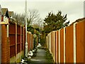
Dead-end back alley off Green Hill Croft
Open Street Map suggested that this was a path into Cabbage Hill open space, which it may have been at one time but is now blocked by a wall at the northern end.
Image: © Stephen Craven
Taken: 17 Jan 2021
0.09 miles
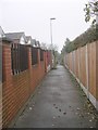
8
Pollarded trees, Green Hill Chase
Some of these are seen, before pollarding, in Image
Image: © Stephen Craven
Taken: 17 Jan 2021
0.09 miles
9
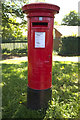
George V Postbox, Green Hill Lane
Near to the Western Flatts Park Bowling Green.
Image: © Mark Anderson
Taken: 31 May 2017
0.09 miles
10
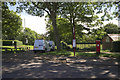
Entrance to Western Flatts Park
A closer view of the postbox can be seen here: Image
Image: © Mark Anderson
Taken: 31 May 2017
0.09 miles