IMAGES TAKEN NEAR TO
Upper Wortley Road, LEEDS, LS12 4FB
Introduction
This page details the photographs taken nearby to Upper Wortley Road, LS12 4FB by members of the Geograph project.
The Geograph project started in 2005 with the aim of publishing, organising and preserving representative images for every square kilometre of Great Britain, Ireland and the Isle of Man.

There are currently over 7.5m images from over14,400 individuals and you can help contribute to the project by visiting https://www.geograph.org.uk
Image Map
Images are licensed for reuse under creativecommons.org/licenses/by-sa/2.0
Notes
- Clicking on the map will re-center to the selected point.
- The higher the marker number, the further away the image location is from the centre of the postcode.
Image Listing (185 Images Found)
Images are licensed for reuse under creativecommons.org/licenses/by-sa/2.0
Image
Details
Distance
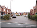
1

Thornhill Road - Upper Wortley Road
Image: © Betty Longbottom
Taken: 8 Nov 2011
0.03 miles
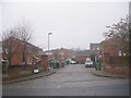
2
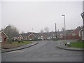
Chestnut Gardens - Upper Wortley Road
Image: © Betty Longbottom
Taken: 8 Nov 2011
0.04 miles
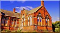
3
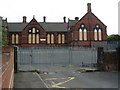
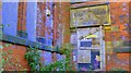
Former Upper Wortley Primary School
This school is located on Upper Wortley Road and served a wide area. School was in two parts, split between two age groups in two buildings.
Image: © Terry Johnson
Taken: 7 Aug 2003
0.05 miles
4
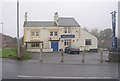
The Golden Fleece - Upper Wortley Road
Image: © Betty Longbottom
Taken: 8 Nov 2011
0.05 miles
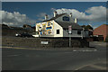
7
Thornhill Croft - Upper Wortley Road
Image: © Betty Longbottom
Taken: 8 Nov 2011
0.06 miles
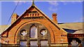
8
Upper Wortley Primary School, Wortley, Leeds
Image: © Mark Stevenson
Taken: 25 Sep 2014
0.07 miles
9
Upper Wortley Primary School, Wortley, Leeds
Image: © Mark Stevenson
Taken: 25 Sep 2014
0.07 miles
10
Upper Wortley Primary School, Wortley, Leeds
Image: © Mark Stevenson
Taken: 25 Sep 2014
0.07 miles