IMAGES TAKEN NEAR TO
Oldfield Avenue, LEEDS, LS12 4EN
Introduction
This page details the photographs taken nearby to Oldfield Avenue, LS12 4EN by members of the Geograph project.
The Geograph project started in 2005 with the aim of publishing, organising and preserving representative images for every square kilometre of Great Britain, Ireland and the Isle of Man.

There are currently over 7.5m images from over14,400 individuals and you can help contribute to the project by visiting https://www.geograph.org.uk
Image Map
Images are licensed for reuse under creativecommons.org/licenses/by-sa/2.0
Notes
- Clicking on the map will re-center to the selected point.
- The higher the marker number, the further away the image location is from the centre of the postcode.
Image Listing (142 Images Found)
Images are licensed for reuse under creativecommons.org/licenses/by-sa/2.0
Image
Details
Distance
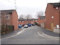
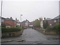
3
Oldfield Avenue - looking towards Oldfield Lane
Image: © Betty Longbottom
Taken: 27 Feb 2012
0.03 miles
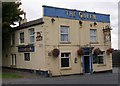
5
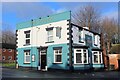
The Queen, Wortley
Hostelry on Oldfield Lane, Wortley daubed with an interesting colour scheme
Image: © Chris Heaton
Taken: 4 Jan 2024
0.04 miles
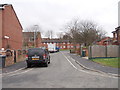
6
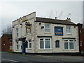
The Queen public house
On Oldfield Road, Leeds.
Image: © Ian S
Taken: 28 Nov 2011
0.05 miles
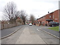
9
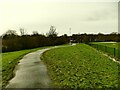
Footpath alongside Five Lanes Primary School
The path cuts across a green space that another contributor describes as once having been "pig and poultry smallholdings" Image
Image: © Stephen Craven
Taken: 17 Jan 2021
0.06 miles
10
Benson Gardens - Upper Wortley Road
Image: © Betty Longbottom
Taken: 8 Nov 2011
0.07 miles