IMAGES TAKEN NEAR TO
Hardrow Road, LEEDS, LS12 4BX
Introduction
This page details the photographs taken nearby to Hardrow Road, LS12 4BX by members of the Geograph project.
The Geograph project started in 2005 with the aim of publishing, organising and preserving representative images for every square kilometre of Great Britain, Ireland and the Isle of Man.

There are currently over 7.5m images from over14,400 individuals and you can help contribute to the project by visiting https://www.geograph.org.uk
Image Map
Images are licensed for reuse under creativecommons.org/licenses/by-sa/2.0
Notes
- Clicking on the map will re-center to the selected point.
- The higher the marker number, the further away the image location is from the centre of the postcode.
Image Listing (127 Images Found)
Images are licensed for reuse under creativecommons.org/licenses/by-sa/2.0
Image
Details
Distance
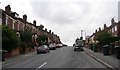
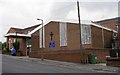
1
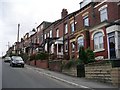
Highfield Avenue - viewed from Hardrow Road
Image: © Betty Longbottom
Taken: 27 Feb 2012
0.02 miles
2
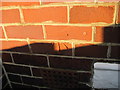
Ordnance Survey Cut Mark on wall of 49 Highfield Avenue, Wortley
This can be found on house front wall between door and bay window.
Image: © Peter Wood
Taken: 14 Jan 2012
0.03 miles
3
Highfield Methodist Church - Highfield Avenue
Image: © Betty Longbottom
Taken: 2 Oct 2007
0.04 miles
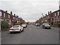
4
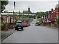
Highfield Avenue, Wortley, Leeds
Looking north-westward.
Image: © Peter Wood
Taken: 19 May 2017
0.04 miles
5
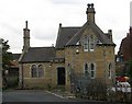
Upper & Lower Wortley Cemetery Lodge
Image: © Betty Longbottom
Taken: 2 Oct 2007
0.04 miles
6
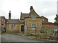
Upper and Lower Wortley Cemetery - north lodge
It appears to have deteriorated since 2007, see Image
Image: © Stephen Craven
Taken: 29 Jun 2020
0.05 miles
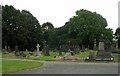
8
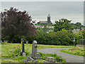
Upper and Lower Wortley Cemetery - view towards Armley
With St Bartholomew's church on the skyline.
Image: © Stephen Craven
Taken: 29 Jun 2020
0.07 miles