IMAGES TAKEN NEAR TO
Dragon Road, LEEDS, LS12 4BA
Introduction
This page details the photographs taken nearby to Dragon Road, LS12 4BA by members of the Geograph project.
The Geograph project started in 2005 with the aim of publishing, organising and preserving representative images for every square kilometre of Great Britain, Ireland and the Isle of Man.

There are currently over 7.5m images from over14,400 individuals and you can help contribute to the project by visiting https://www.geograph.org.uk
Image Map
Images are licensed for reuse under creativecommons.org/licenses/by-sa/2.0
Notes
- Clicking on the map will re-center to the selected point.
- The higher the marker number, the further away the image location is from the centre of the postcode.
Image Listing (115 Images Found)
Images are licensed for reuse under creativecommons.org/licenses/by-sa/2.0
Image
Details
Distance
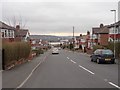
1
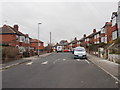
Lynwood Crescent - viewed from Dragon Road
Image: © Betty Longbottom
Taken: 27 Feb 2012
0.02 miles
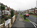
2
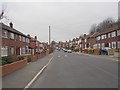
Dragon Road - viewed from Highfield Close
Image: © Betty Longbottom
Taken: 27 Feb 2012
0.02 miles
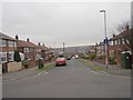
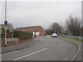
3
Dragon Road - viewed from Dragon Drive
Image: © Betty Longbottom
Taken: 27 Feb 2012
0.02 miles

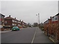
5
Highfield Close - viewed from Highfield Avenue
Image: © Betty Longbottom
Taken: 27 Feb 2012
0.03 miles
8
Highfield Garth - Highfield Avenue
Image: © Betty Longbottom
Taken: 27 Feb 2012
0.04 miles
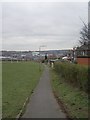
10
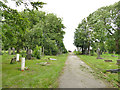
Upper and Lower Wortley Cemetery - old section
This original cemetery has become full, and burials now take place in a field to the west Image
Image: © Stephen Craven
Taken: 29 Jun 2020
0.06 miles