IMAGES TAKEN NEAR TO
The Heights West, LEEDS, LS12 3TY
Introduction
This page details the photographs taken nearby to The Heights West, LS12 3TY by members of the Geograph project.
The Geograph project started in 2005 with the aim of publishing, organising and preserving representative images for every square kilometre of Great Britain, Ireland and the Isle of Man.

There are currently over 7.5m images from over14,400 individuals and you can help contribute to the project by visiting https://www.geograph.org.uk
Image Map
Images are licensed for reuse under creativecommons.org/licenses/by-sa/2.0
Notes
- Clicking on the map will re-center to the selected point.
- The higher the marker number, the further away the image location is from the centre of the postcode.
Image Listing (136 Images Found)
Images are licensed for reuse under creativecommons.org/licenses/by-sa/2.0
Image
Details
Distance
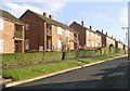
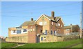
1
The Heights West, Pudsey Road
Image: © Stephen Craven
Taken: 29 Aug 2015
0.00 miles
4
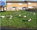
Reservoir Ducks - Pudsey Road
These would appear to have taken 'flight'from the nearby reservoir.
Image: © Betty Longbottom
Taken: 10 Dec 2007
0.03 miles
5
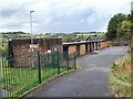
Burnt-out lockups off Farrow Bank, Farnley
I expect these garages will get demolished soon.
Image: © Stephen Craven
Taken: 9 Sep 2022
0.03 miles
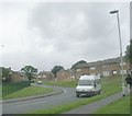
9
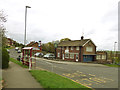
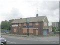
The former Nook pub, Heights Drive
Described in a CAMRA guide to Leeds pubs published in 1993 as a 'large entertainment oriented estate pub' serving John Smith's beers. Betty Longbottom's two views in 2007 Image and 2011 Image show that it closed some time between those dates. It has now been converted to a house but still retains the John Smiths sign outside. In the foreground is a bus shelter on the 15 route.
Image: © Stephen Craven
Taken: 28 Apr 2018
0.07 miles