IMAGES TAKEN NEAR TO
Moorfield Road, LEEDS, LS12 3SE
Introduction
This page details the photographs taken nearby to Moorfield Road, LS12 3SE by members of the Geograph project.
The Geograph project started in 2005 with the aim of publishing, organising and preserving representative images for every square kilometre of Great Britain, Ireland and the Isle of Man.

There are currently over 7.5m images from over14,400 individuals and you can help contribute to the project by visiting https://www.geograph.org.uk
Image Map
Images are licensed for reuse under creativecommons.org/licenses/by-sa/2.0
Notes
- Clicking on the map will re-center to the selected point.
- The higher the marker number, the further away the image location is from the centre of the postcode.
Image Listing (273 Images Found)
Images are licensed for reuse under creativecommons.org/licenses/by-sa/2.0
Image
Details
Distance
1
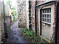
Path behind Hawthorn Cottage, Armley
The path is a right of way probably predating the house itself, which is already shown on the 1908 map. This back door onto the footpath has been blocked up at some time.
Image: © Stephen Craven
Taken: 1 Jul 2020
0.00 miles
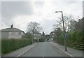
2
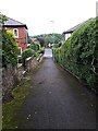
Path from Moorfield Park to Armley Grange View
Image: © Stephen Craven
Taken: 1 Jul 2020
0.03 miles
3
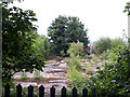
Tower Works site, Armley
This site behind Moorfield Street was a factory that manufactured meters (originally the Leeds Meter Company, later Kent Meters then ABB Kents). The factory was demolished some time ago and planning permission was granted in 2017 for it to be developed for housing. By July 2020 construction was yet to start.
Image: © Stephen Craven
Taken: 1 Jul 2020
0.03 miles
5
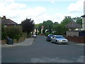
Armley Grange View - looking towards Armley Grange Avenue
Image: © Betty Longbottom
Taken: 31 May 2011
0.04 miles
6
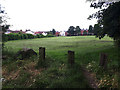
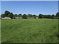
Moorfield Park, Armley from the north end
See Image for a view from the other end.
Image: © Stephen Craven
Taken: 1 Jul 2020
0.05 miles
7
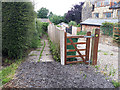
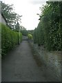
Footpath off Tower Lane, Armley
The official right of way passes through the small gate, down the private drive of no. 48 and through another gate. The de-facto path is to the left.
Image: © Stephen Craven
Taken: 1 Jul 2020
0.06 miles
8
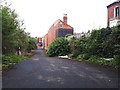
Back Moorfield Street, Armley
This partly overgrown road will hopefully be improved as part of a forthcoming housing development on the former industrial land to the left Image
Image: © Stephen Craven
Taken: 1 Jul 2020
0.06 miles
9
Moorfield Park, Armley
A recreation ground with a full-length football pitch.
Image: © Stephen Craven
Taken: 25 Jun 2020
0.06 miles
10
Armley Grange View - Armley Grange Avenue
Image: © Betty Longbottom
Taken: 13 Apr 2009
0.07 miles