IMAGES TAKEN NEAR TO
Armley Grange Mount, LEEDS, LS12 3QB
Introduction
This page details the photographs taken nearby to Armley Grange Mount, LS12 3QB by members of the Geograph project.
The Geograph project started in 2005 with the aim of publishing, organising and preserving representative images for every square kilometre of Great Britain, Ireland and the Isle of Man.

There are currently over 7.5m images from over14,400 individuals and you can help contribute to the project by visiting https://www.geograph.org.uk
Image Map
Images are licensed for reuse under creativecommons.org/licenses/by-sa/2.0
Notes
- Clicking on the map will re-center to the selected point.
- The higher the marker number, the further away the image location is from the centre of the postcode.
Image Listing (204 Images Found)
Images are licensed for reuse under creativecommons.org/licenses/by-sa/2.0
Image
Details
Distance
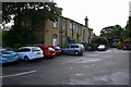
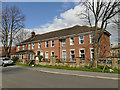
1
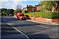
Houses on Armley Grange Mount
Two pairs of semi-detached houses with some unusual detailing, such as the front profile that is partly gabled and partly a mansard roof, rear dormers and a variety of side windows.
Image: © Stephen Craven
Taken: 29 Mar 2020
0.02 miles
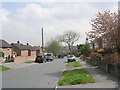
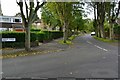
2
Armley Grange Rise - Armley Grange Mount
Image: © Betty Longbottom
Taken: 13 Apr 2009
0.04 miles
3
Armley Grange Avenue - viewed from Armley Grange Mount
Image: © Betty Longbottom
Taken: 13 Apr 2009
0.06 miles
5
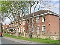
The Spinney Residential Home for the Elderly - Armley Grange Drive
Image: © Betty Longbottom
Taken: 13 Apr 2009
0.07 miles
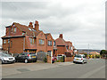
6
The Spinney, Armley Grange Drive
A residential care home within the grounds of the former 19th century mansion Image
Image: © Stephen Craven
Taken: 29 Mar 2020
0.07 miles
7
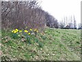
Early daffodils on Hill Top Moor, Armley
This is a 'moor' not in the sense of unenclosed uplands, but in the dialect sense of a public open space. According to the Leodis website, it is all that remains of the former common lands of Armley, used as a tenterfield until the 1850s. See Image
Image: © Stephen Craven
Taken: 11 Mar 2022
0.07 miles
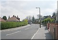
9
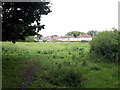
Hill Top Moor, Armley
This is a 'moor' not in the sense of unenclosed uplands, but in the dialect sense of a public open space. According to the Leodis website, it is all that remains of the former common lands of Armley, used as a tenterfield until the 1850s. It is currently used for horse grazing.
Image: © Stephen Craven
Taken: 1 Jul 2020
0.08 miles