IMAGES TAKEN NEAR TO
Green Hill Road, LEEDS, LS12 3PZ
Introduction
This page details the photographs taken nearby to Green Hill Road, LS12 3PZ by members of the Geograph project.
The Geograph project started in 2005 with the aim of publishing, organising and preserving representative images for every square kilometre of Great Britain, Ireland and the Isle of Man.

There are currently over 7.5m images from over14,400 individuals and you can help contribute to the project by visiting https://www.geograph.org.uk
Image Map
Images are licensed for reuse under creativecommons.org/licenses/by-sa/2.0
Notes
- Clicking on the map will re-center to the selected point.
- The higher the marker number, the further away the image location is from the centre of the postcode.
Image Listing (187 Images Found)
Images are licensed for reuse under creativecommons.org/licenses/by-sa/2.0
Image
Details
Distance
1
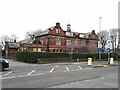
Green Hill House, Green Hill Road, Armley
This building appeared on the OS map between the 1893 and 1908 editions, but unlabelled. The 1935 map shows it as the 'Relief Offices of the Leeds Public Assistance Committee'. In 1957 and 1968 it is labelled as a hostel, but is now divided into twelve flats. See also Image
Image: © Stephen Craven
Taken: 11 Mar 2022
0.00 miles
2
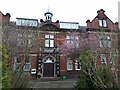
Entrance to Green Hill House
This building appeared on the OS map between the 1893 and 1908 editions, but unlabelled. The 1935 map shows it as the 'Relief Offices of the Leeds Public Assistance Committee'. In 1957 and 1968 it is labelled as a hostel, but is now divided into twelve flats. See Image for context.
Image: © Stephen Craven
Taken: 11 Mar 2022
0.00 miles
3
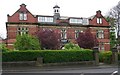
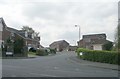
Armley Grange Mount - Green Hill Road
Image: © Betty Longbottom
Taken: 13 Apr 2009
0.02 miles
4
Green Hill House - Green Hill Lane
Image: © Betty Longbottom
Taken: 14 May 2007
0.02 miles
6
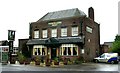
The Travellers Rest, Hill Top, Armley
This Greene King pub is at the top of a hill, but not a long or steep one. It first appears on the 1921 OS map, and from the style was probably built not long before that.
Image: © Stephen Craven
Taken: 11 Mar 2022
0.03 miles
7
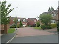
St Mary's Park Green - St Mary's Park Approach
Image: © Betty Longbottom
Taken: 25 Jul 2011
0.05 miles
8
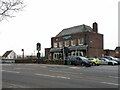
St Mary's Park Approach, Armley
Despite the name there is no park at the end of this road, unless you count a small green space of a quarter of a hectare Image 'Approach' here just means it's the spine road of a housing estate.
Image: © Stephen Craven
Taken: 11 Mar 2022
0.05 miles
9
St Mary's Park Approach - Green Hill Road
Image: © Betty Longbottom
Taken: 13 Apr 2009
0.06 miles
10
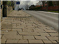
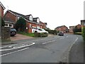
Stone pavement, Green Hill Road,
This sort of traditional York stone paving, with stone setts to the driveways, has all too often been replaced with tarmac or concrete flags.
Image: © Stephen Craven
Taken: 29 Mar 2020
0.06 miles