IMAGES TAKEN NEAR TO
Halliday Road, LEEDS, LS12 3PG
Introduction
This page details the photographs taken nearby to Halliday Road, LS12 3PG by members of the Geograph project.
The Geograph project started in 2005 with the aim of publishing, organising and preserving representative images for every square kilometre of Great Britain, Ireland and the Isle of Man.

There are currently over 7.5m images from over14,400 individuals and you can help contribute to the project by visiting https://www.geograph.org.uk
Image Map
Images are licensed for reuse under creativecommons.org/licenses/by-sa/2.0
Notes
- Clicking on the map will re-center to the selected point.
- The higher the marker number, the further away the image location is from the centre of the postcode.
Image Listing (276 Images Found)
Images are licensed for reuse under creativecommons.org/licenses/by-sa/2.0
Image
Details
Distance
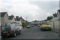
5
Moorfield Park, Armley from the north end
See Image for a view from the other end.
Image: © Stephen Craven
Taken: 1 Jul 2020
0.03 miles
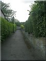
6

Footpath from the end of Halliday Drive
The path runs round the edge of the playing fields to reach Armley Grange View. For most of its length it is wide enough for vehicles.
Image: © Stephen Craven
Taken: 25 Jun 2020
0.04 miles
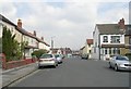
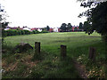
8
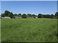
Moorfield Park, Armley
A recreation ground with a full-length football pitch.
Image: © Stephen Craven
Taken: 25 Jun 2020
0.04 miles