IMAGES TAKEN NEAR TO
Hollywell Grove, LEEDS, LS12 3HR
Introduction
This page details the photographs taken nearby to Hollywell Grove, LS12 3HR by members of the Geograph project.
The Geograph project started in 2005 with the aim of publishing, organising and preserving representative images for every square kilometre of Great Britain, Ireland and the Isle of Man.

There are currently over 7.5m images from over14,400 individuals and you can help contribute to the project by visiting https://www.geograph.org.uk
Image Map
Images are licensed for reuse under creativecommons.org/licenses/by-sa/2.0
Notes
- Clicking on the map will re-center to the selected point.
- The higher the marker number, the further away the image location is from the centre of the postcode.
Image Listing (399 Images Found)
Images are licensed for reuse under creativecommons.org/licenses/by-sa/2.0
Image
Details
Distance
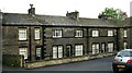
2
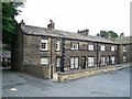
Hollywell Grove, Holywell Lane, Armley
Described as a pair of 19th cent houses it could be that the central section of double fronts with quoins was the original and the two end houses added later.
Image: © Stanley Walker
Taken: 8 Aug 2008
0.02 miles
3
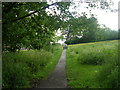
Footpath across Armley Common - viewed from Theaker Lane
Image: © Betty Longbottom
Taken: 31 May 2011
0.03 miles
4
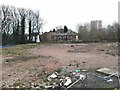
Site of the former Men's Institute, Armley
According to the Secret Leeds discussion forum, the Upper Armley Christ Church Men's Institute originally stood on this site, which later became the Upstairs Downstairs nightclub Image It burnt down in October 2018 and the site has been cleared pending future development.
Image: © Stephen Craven
Taken: 11 Mar 2022
0.04 miles
5
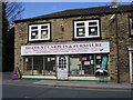
Discount Carpets & Furniture - Town Street
Image: © Betty Longbottom
Taken: 4 Apr 2010
0.04 miles
7
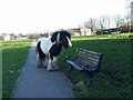
Horse on a path, Armley Moor
The recreation ground is, according to a local history website, common land following the Inclosure Act of 1793, which allocated this open space as a tenterfield. The only vestige of commoner's usage today is the horses that are sometimes to be seen grazing on the moor. This one was on a long tether, but was rather unkempt and surrounded by a swarm of flies, so I didn't greet it closely.
Image: © Stephen Craven
Taken: 29 Mar 2021
0.04 miles
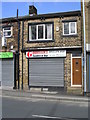
8
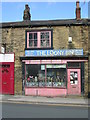
Bernard Lever Optician - Town Street
Image: © Betty Longbottom
Taken: 4 Apr 2010
0.04 miles
9
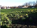
Daffodils on Armley Moor
The recreation ground is, according to a local history website, common land following the Inclosure Act of 1793.
Image: © Stephen Craven
Taken: 29 Mar 2021
0.04 miles
10
Goodfiller'z Sandwich Bar - Town Street
Image: © Betty Longbottom
Taken: 4 Apr 2010
0.05 miles