IMAGES TAKEN NEAR TO
Cockshott Drive, LEEDS, LS12 2RL
Introduction
This page details the photographs taken nearby to Cockshott Drive, LS12 2RL by members of the Geograph project.
The Geograph project started in 2005 with the aim of publishing, organising and preserving representative images for every square kilometre of Great Britain, Ireland and the Isle of Man.

There are currently over 7.5m images from over14,400 individuals and you can help contribute to the project by visiting https://www.geograph.org.uk
Image Map
Images are licensed for reuse under creativecommons.org/licenses/by-sa/2.0
Notes
- Clicking on the map will re-center to the selected point.
- The higher the marker number, the further away the image location is from the centre of the postcode.
Image Listing (207 Images Found)
Images are licensed for reuse under creativecommons.org/licenses/by-sa/2.0
Image
Details
Distance
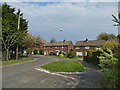
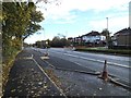
1
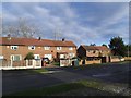
Cockshott Drive, Wyther
Houses under a power line.
Image: © Stephen Craven
Taken: 7 Nov 2015
0.01 miles
2
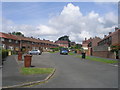
Cockshott Drive - looking towards Cockshott Lane
Image: © Betty Longbottom
Taken: 12 Jul 2011
0.02 miles
3
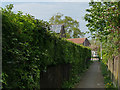
Ginnel to Cockshott Drive
See Image for a view in the opposite direction.
Image: © Stephen Craven
Taken: 26 Apr 2020
0.03 miles
4
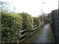
Ginnel from Cockshott Drive to Stanningley Road
See Image for a view in the other direction.
Image: © Stephen Craven
Taken: 7 Nov 2015
0.04 miles
5
Houses on Cockshott Drive
Near the end of this dead-end street.
Image: © Stephen Craven
Taken: 26 Apr 2020
0.04 miles
6
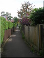
Footpath linking Stanningley Road & Cockshott Drive
Image: © Betty Longbottom
Taken: 12 Jul 2011
0.05 miles
7

Traffic camera on Stanningley Road
This isn't the usual type of speed camera. It is intended to enforce the "2+ Lane" (the inner traffic lane is only open to buses and cars with more than one occupant in rush hour). In practice, as soon as drivers pass this, they revert to type - I have counted more than 75% of vehicles in this lane being single-occupancy. Pretty irrelevant at present, with the Covid-19 restrictions traffic even on weekday mornings is very light.
Image: © Stephen Craven
Taken: 26 Apr 2020
0.05 miles
8
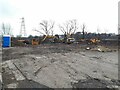
Site of the Wyther Hotel, Cockshott Lane
The 1968 map shows a pub and one other building on this site with an open field behind. Local websites say the pub was originally called the Wyther Hotel, later renamed The Yorkshireman, demolished in 2004. A CAMRA guide to Leeds pubs published in 1993 notes it as being a Tetley pub with lounge, snug and taproom.
Work has recently started on a new development (Planning application 19/01670 by MD Construction Ltd, for 'Eleven houses, one block of four bungalows with staff facilities and one block of thirteen flats with one staff accommodation unit'). The reference to staff suggests some kind of sheltered or supported living accommodation.
Image: © Stephen Craven
Taken: 11 Feb 2022
0.06 miles
10
Stanningley Road with bus stop and cycle lane
At this time the Leeds-Bradford cycle "superhighway" was not yet officially open but some sections such as this were physically complete. The "floating" bus stop still had a temporary sign, presumably with a shelter to follow.
Image: © Stephen Craven
Taken: 7 Nov 2015
0.06 miles