IMAGES TAKEN NEAR TO
Lenhurst Avenue, LEEDS, LS12 2RE
Introduction
This page details the photographs taken nearby to Lenhurst Avenue, LS12 2RE by members of the Geograph project.
The Geograph project started in 2005 with the aim of publishing, organising and preserving representative images for every square kilometre of Great Britain, Ireland and the Isle of Man.

There are currently over 7.5m images from over14,400 individuals and you can help contribute to the project by visiting https://www.geograph.org.uk
Image Map
Images are licensed for reuse under creativecommons.org/licenses/by-sa/2.0
Notes
- Clicking on the map will re-center to the selected point.
- The higher the marker number, the further away the image location is from the centre of the postcode.
Image Listing (305 Images Found)
Images are licensed for reuse under creativecommons.org/licenses/by-sa/2.0
Image
Details
Distance
1
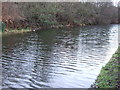
The Leeds to Liverpool at Kirkstall.
Looking SE to where the canal joins this particular square.
Image: © Steve Partridge
Taken: 26 Feb 2006
0.00 miles
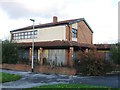
2
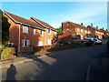
Houses on Lenhurst Avenue
The street originally gave access to a secondary school (and now to the West Leeds Activity Centre that replaced it), and also has a small number of modern houses.
Image: © Stephen Craven
Taken: 5 May 2020
0.01 miles
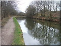
3
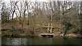
Private jetty on Leeds and Liverpool Canal
Image: © Chris Morgan
Taken: 17 Mar 2014
0.03 miles
4
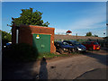
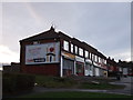
Substation off Armley Ridge Road
Tucked away behind a small shopping parade Image along with a small car park.
Image: © Stephen Craven
Taken: 5 May 2020
0.04 miles
5
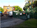
Entrance to the West Leeds Activity Centre
I expected this would be closed in the Covid-19 lockdown, but I saw a vehicle enter the keypad-controlled gates, and inside was a minibus with some young people outside it (deliberately not included in the photo).
Image: © Stephen Craven
Taken: 5 May 2020
0.04 miles
6
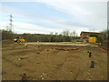
Piling for new houses at Amen Corner (2)
The site of the former Ancestor pub Image At the time of a CAMRA guide to Leeds pubs published in 1993 it was called 'Warrens', and was described as a 1960s built estate pub. By 2017 the site had been cleared and levelled, and a piling rig Image was now driving metal piles to support a new development of houses for a housing association.
Image: © Stephen Craven
Taken: 9 Dec 2017
0.04 miles
7
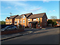
Houses on Ancestor Close
This short street of social housing off Lenhurst Avenue was built in 2018/19 on and behind the site of the former Ancestor pub Image See Image for the construction phase.
Image: © Stephen Craven
Taken: 5 May 2020
0.04 miles