IMAGES TAKEN NEAR TO
Canal Road, LEEDS, LS12 2LX
Introduction
This page details the photographs taken nearby to Canal Road, LS12 2LX by members of the Geograph project.
The Geograph project started in 2005 with the aim of publishing, organising and preserving representative images for every square kilometre of Great Britain, Ireland and the Isle of Man.

There are currently over 7.5m images from over14,400 individuals and you can help contribute to the project by visiting https://www.geograph.org.uk
Image Map
Images are licensed for reuse under creativecommons.org/licenses/by-sa/2.0
Notes
- Clicking on the map will re-center to the selected point.
- The higher the marker number, the further away the image location is from the centre of the postcode.
Image Listing (665 Images Found)
Images are licensed for reuse under creativecommons.org/licenses/by-sa/2.0
Image
Details
Distance
1
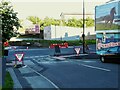
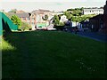
The bottom of Armley Park Road
This end of the road has recently been narrowed to a single lane and is a 'point no entry' (i.e, vehicles are not allowed into it at this end but the street itself is not one-way). Temporary signage was in place until traffic lights could be erected Image
Image: © Stephen Craven
Taken: 18 May 2021
0.01 miles
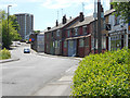
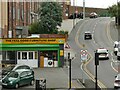
3
The north end of Pickering Street
The junction with Canal Road has only had traffic lights added this year (2021), with Armley Park Road the other side being made no entry Image The stop line this side is set well back to allow lorries accessing an industrial estate to sweep round.
Image: © Stephen Craven
Taken: 23 Oct 2021
0.01 miles
4

View from Bridge TJC3-20 - Canal Road, Armley
Image: © Betty Longbottom
Taken: 20 Oct 2008
0.02 miles
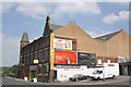
5
Jillings Baddeley, Canal Road, Armley
An upholstery business. The building occupies the site of a row of houses shown on an old map as "Malta" (possibly nicknamed from the nearby Tetley maltings?)
Image: © Stephen Craven
Taken: 18 May 2021
0.02 miles
6
Green space alongside Armley Park Road
Looking at old maps this triangular space between the road and railway cutting has never been built on apart from a few houses (no longer extant) at the bottom. Maybe because it was thought there would be too high a risk of the ground slipping into the steep cutting.
Image: © Stephen Craven
Taken: 18 May 2021
0.02 miles
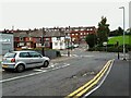
7
Pickering Street: wrong signage
A newly added road sign indicates a downhill gradient of 15%, but as is evident from this photo, the gradient is uphill.
Image: © Stephen Craven
Taken: 4 Jul 2022
0.03 miles
8
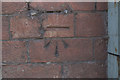
Benchmark on furniture store at #44-46 Canal Road
Ordnance Survey cut mark benchmark described on the Bench Mark Database at http://www.bench-marks.org.uk/bm50415
Image: © Roger Templeman
Taken: 6 Jul 2013
0.03 miles
9
Furniture & Carpet warehouse, #44-46 Canal Road
There is an OS benchmark Image on the near corner of the warehouse below the green 'carpets' sign
Image: © Roger Templeman
Taken: 6 Jul 2013
0.03 miles
10
Cut Bench Mark, Canal Road Furniture Store
Bench Mark Database: http://www.bench-marks.org.uk/bm50415
Image: © Mark Anderson
Taken: 25 May 2017
0.03 miles