IMAGES TAKEN NEAR TO
Armley Road, LEEDS, LS12 2LL
Introduction
This page details the photographs taken nearby to Armley Road, LS12 2LL by members of the Geograph project.
The Geograph project started in 2005 with the aim of publishing, organising and preserving representative images for every square kilometre of Great Britain, Ireland and the Isle of Man.

There are currently over 7.5m images from over14,400 individuals and you can help contribute to the project by visiting https://www.geograph.org.uk
Image Map
Images are licensed for reuse under creativecommons.org/licenses/by-sa/2.0
Notes
- Clicking on the map will re-center to the selected point.
- The higher the marker number, the further away the image location is from the centre of the postcode.
Image Listing (471 Images Found)
Images are licensed for reuse under creativecommons.org/licenses/by-sa/2.0
Image
Details
Distance
1
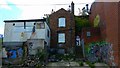
Houses on Fielding Gate, Armley
The houses overlook the main Armley Road which is currently being widened.
Image: © Stephen Craven
Taken: 29 Mar 2021
0.01 miles
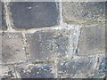
2
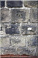
Benchmark on Armley Road wall
Ordnance Survey cut mark benchmark described on the Bench Mark Database at http://www.bench-marks.org.uk/bm40983
Image: © Roger Templeman
Taken: 4 Aug 2016
0.02 miles
4
Ordnance Survey Cut Mark on wall in Armley Road, Armley
It can be found on the south-east side of the road beside a path leading to some flats.
Image: © Peter Wood
Taken: 14 Jan 2012
0.02 miles
5
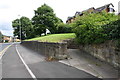
Footpath from Armley Road towards Mistress Lane
There is an OS benchmark Image on the wall, on the 9th stone beyond the path entrance
Image: © Roger Templeman
Taken: 4 Aug 2016
0.03 miles
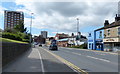
7

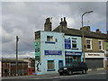
Shops and former pub, Armley Road
The end nearest the camera was the Rose and Crown pub Image A CAMRA guide to Leeds pubs published in 1993 notes it as being a Melbourne Brewery pub, with decorative glass, mosaics and a mural. It has now been converted to two houses.
Image: © Stephen Craven
Taken: 16 Jan 2022
0.03 miles
8
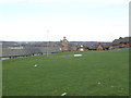
Open space below Mistress Lane, Armley
Looking down towards buildings on Armley Road.
Image: © Stephen Craven
Taken: 9 Dec 2017
0.03 miles
9
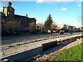
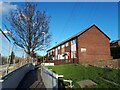
Road widening, Armley Road (3)
Leeds City Council was widening the road up to and around the junction with Stanningley Road and Branch Road, mainly to give priority to buses and cyclists. See Image for a previous view of roughly the same location.
Image: © Stephen Craven
Taken: 29 Mar 2021
0.03 miles