IMAGES TAKEN NEAR TO
Fielding Gate Mews, LEEDS, LS12 2JH
Introduction
This page details the photographs taken nearby to Fielding Gate Mews, LS12 2JH by members of the Geograph project.
The Geograph project started in 2005 with the aim of publishing, organising and preserving representative images for every square kilometre of Great Britain, Ireland and the Isle of Man.

There are currently over 7.5m images from over14,400 individuals and you can help contribute to the project by visiting https://www.geograph.org.uk
Image Map
Images are licensed for reuse under creativecommons.org/licenses/by-sa/2.0
Notes
- Clicking on the map will re-center to the selected point.
- The higher the marker number, the further away the image location is from the centre of the postcode.
Image Listing (426 Images Found)
Images are licensed for reuse under creativecommons.org/licenses/by-sa/2.0
Image
Details
Distance
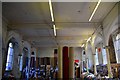
1
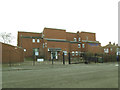
Armley Manor
Student accommodation on Mistress Lane.
Image: © Stephen Craven
Taken: 9 Dec 2017
0.03 miles
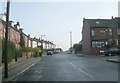
2
Fielding Gate - Mistress Lane, Armley
Image: © Betty Longbottom
Taken: 3 Nov 2008
0.03 miles
3
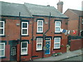
A typical day Aviary Place
clean washing drying on the line
Image: © john casewell
Taken: 24 Jul 2004
0.04 miles
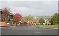
5
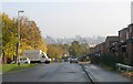
Ley Lane viewed from Mistress Lane, Armley
Image: © Betty Longbottom
Taken: 3 Nov 2008
0.05 miles
6
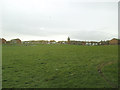
Open space below Mistress Lane, Armley
Looking down towards buildings on Armley Road.
Image: © Stephen Craven
Taken: 9 Dec 2017
0.05 miles
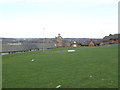
7
Armley Recreation Ground
An open space of about 1.9 hectares.
Image: © Stephen Craven
Taken: 9 Dec 2017
0.05 miles

10

Recreation Ground - Albion Avenue
Image: © Betty Longbottom
Taken: 10 Jan 2012
0.07 miles