IMAGES TAKEN NEAR TO
Wensleydale Drive, LEEDS, LS12 2HU
Introduction
This page details the photographs taken nearby to Wensleydale Drive, LS12 2HU by members of the Geograph project.
The Geograph project started in 2005 with the aim of publishing, organising and preserving representative images for every square kilometre of Great Britain, Ireland and the Isle of Man.

There are currently over 7.5m images from over14,400 individuals and you can help contribute to the project by visiting https://www.geograph.org.uk
Image Map
Images are licensed for reuse under creativecommons.org/licenses/by-sa/2.0
Notes
- Clicking on the map will re-center to the selected point.
- The higher the marker number, the further away the image location is from the centre of the postcode.
Image Listing (160 Images Found)
Images are licensed for reuse under creativecommons.org/licenses/by-sa/2.0
Image
Details
Distance
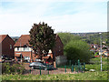
1
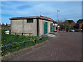
Substation on Wensleydale Crescent
Named 'Wyther Park substation' (the name of the wider housing estate). Just beyond it is where the Wyther Hostel once stood - a "mother and baby home" offering pre- and post-natal care for up to 30 women.
Image: © Stephen Craven
Taken: 23 Apr 2020
0.04 miles
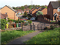
2
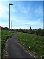
Link path beyond Wensleydale Crescent
This path links the crescent to the serpentine path that runs up the hill between two parts of the estate.
Image: © Stephen Craven
Taken: 23 Apr 2020
0.04 miles
4
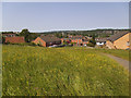
Path above Raynville Crescent in Spring
This time of year, two years earlier, the grass had been cut short Image This year, it is still long, with meadow flowers. Deliberate policy or council cuts?
Image: © Stephen Craven
Taken: 27 May 2018
0.05 miles
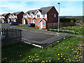
5
The official exit from Borrowdale Crescent
Borrowdale Crescent terminates in two 'prongs'; only this one has a proper pedestrian exit (with cycle barrier), unlike the other Image
Image: © Stephen Craven
Taken: 23 Apr 2020
0.06 miles
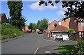
6
Wensleydale Avenue
Like most of the streets on this estate it is linked to the path running through the spine of the estate. There used to be an earlier generation of inter-war housing here, called Houghley Grove.
Image: © Stephen Craven
Taken: 23 Apr 2020
0.06 miles
7
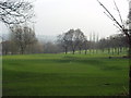
Gotts Park Golf Course, Armley, Leeds
The municipal golf course seen from Armley Ridge Road near the junction of Cockshott Lane. The foreground is just in SE2534, but the flag on the green is probably in SE2634.
Image: © Rich Tea
Taken: 24 Jan 2006
0.06 miles
8
The end of Wensleydale Close
It can be seen that there is a path (which links the crescent to the serpentine path that runs up the hill between two parts of the estate), but a wooden barrier has been erected that also crosses the path, limiting access to the more able-bodied residents.
Image: © Stephen Craven
Taken: 23 Apr 2020
0.06 miles
9
Social housing, Wensleydale Crescent
Housing provided by Leeds Federated Housing Association.
Image: © Stephen Craven
Taken: 22 May 2016
0.06 miles
10
Dead end off Wensleydale Crescent
One might expect steps down from the end of this street to the main road (Cockshott Lane) below, but there is only a tall railing.
Image: © Stephen Craven
Taken: 23 Apr 2020
0.07 miles