IMAGES TAKEN NEAR TO
Maybrook Industrial Park, Armley Road, LEEDS, LS12 2EL
Introduction
This page details the photographs taken nearby to Maybrook Industrial Park, Armley Road, LS12 2EL by members of the Geograph project.
The Geograph project started in 2005 with the aim of publishing, organising and preserving representative images for every square kilometre of Great Britain, Ireland and the Isle of Man.

There are currently over 7.5m images from over14,400 individuals and you can help contribute to the project by visiting https://www.geograph.org.uk
Image Map
Images are licensed for reuse under creativecommons.org/licenses/by-sa/2.0
Notes
- Clicking on the map will re-center to the selected point.
- The higher the marker number, the further away the image location is from the centre of the postcode.
Image Listing (327 Images Found)
Images are licensed for reuse under creativecommons.org/licenses/by-sa/2.0
Image
Details
Distance
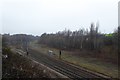
2
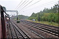
Railway Junction
It looks like the other line was once quadruple track. Seen from the diesel hauled leg of the 'Hadrian' running from Leicester to Hellifield before being steam hauled to York via Carlisle.
Image: © Ashley Dace
Taken: 9 Oct 2010
0.07 miles
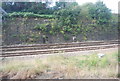
3
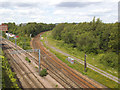
Armley Junction
Four tracks coming out of Leeds split here into two to Skipton (left) and two to Harrogate (right). The sidings either side of the Harrogate line have long since been removed and become overgrown.
Image: © Stephen Craven
Taken: 18 Jun 2019
0.08 miles
4
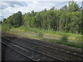
Armley Junction
The diverging Harrogate lines, as seen from a train approaching Leeds on the Skipton line.
Image: © Stephen Craven
Taken: 14 Aug 2016
0.09 miles
5
Harrogate and Bradford lines diverge
The lines west of Leeds diverge here to head to Harrogate (ahead, unelectrified) and Bradford (left, electrified).
Image: © DS Pugh
Taken: 10 Mar 2018
0.09 miles
7
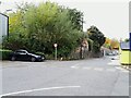
Old stone boundary wall
In the 19th century this wall marked the boundary between the Albion armament works (this side) and the Leeds Iron Forge the other side. It still represents a boundary, between the Albion and Maybrook industrial estates - there's another access road just the other side but no direct connection between them.
Image: © Stephen Craven
Taken: 23 Oct 2021
0.10 miles
8
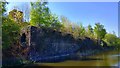
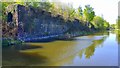
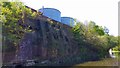
The Leeds Forge, Leeds And Liverpool Canal, Leeds
Remaining foundations of the Leeds Forge as seen from the Leeds Liverpool Canal towpath.
Image: © Mark Stevenson
Taken: 9 May 2016
0.10 miles
9
The Leeds Forge, Leeds And Liverpool Canal, Leeds
Remaining foundations of the Leeds Forge as seen from the Leeds Liverpool Canal towpath.
Image: © Mark Stevenson
Taken: 9 May 2016
0.10 miles
10
The Leeds Forge, Leeds And Liverpool Canal, Leeds
Remaining foundations of the Leeds Forge as seen from the Leeds Liverpool Canal towpath.
Image: © Mark Stevenson
Taken: 9 May 2016
0.10 miles