IMAGES TAKEN NEAR TO
Armley Lodge Road, LEEDS, LS12 2AT
Introduction
This page details the photographs taken nearby to Armley Lodge Road, LS12 2AT by members of the Geograph project.
The Geograph project started in 2005 with the aim of publishing, organising and preserving representative images for every square kilometre of Great Britain, Ireland and the Isle of Man.

There are currently over 7.5m images from over14,400 individuals and you can help contribute to the project by visiting https://www.geograph.org.uk
Image Map
Images are licensed for reuse under creativecommons.org/licenses/by-sa/2.0
Notes
- Clicking on the map will re-center to the selected point.
- The higher the marker number, the further away the image location is from the centre of the postcode.
Image Listing (587 Images Found)
Images are licensed for reuse under creativecommons.org/licenses/by-sa/2.0
Image
Details
Distance
1

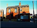
Back of Building - Armley Lodge Road, Armley
Image: © Betty Longbottom
Taken: 20 Oct 2008
0.02 miles

3
S S Stores, Salisbury View, Armley
One of several convenience stores on this estate of mostly back-to-back brick terraced houses.
Image: © Stephen Craven
Taken: 18 May 2021
0.02 miles

5
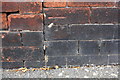
Benchmark on #2 Salisbury Terrace
Ordnance Survey cut mark benchmark described on the Bench Mark Database at http://www.bench-marks.org.uk/bm40969
Image: © Roger Templeman
Taken: 4 Aug 2016
0.02 miles
6
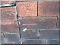
Ordnance Survey Cut Mark on wall of 2 Salisbury Terrace, Armley
Can be found on wall of house.
Image: © Peter Wood
Taken: 14 Jan 2012
0.03 miles
7

Building - Armley Lodge Road, Armley
Image: © Betty Longbottom
Taken: 20 Oct 2008
0.03 miles
8
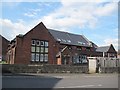
Former St Hugh's school and church, Aviary Mount, Leeds
St Hugh's church (the nave of which can be seen behind the school building) was built in 1909, designed by local architects Chorley and Connon. The school was built on the same site, either at the same time or later. The date of closure is unknown at the time of submission, but I have found a reference to them still being open in 1953. Both church and school have now been converted to apartments ("St Hugh's Lodge").
Image: © Stephen Craven
Taken: 21 Jun 2016
0.03 miles
9
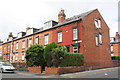
Houses of Salisbury Terrace at Armley Lodge Road junction
There is an OS benchmark Image on the gable end of the nearest house at its junction with the front garden side wall
Image: © Roger Templeman
Taken: 4 Aug 2016
0.03 miles
10
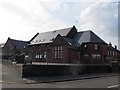
Former St Hugh's school and church, Arley Place, Leeds
St Hugh's church (the apsidal east end of which can be seen in this view) was built in 1909, designed by local architects Chorley and Connon. The school was built on the same site, either at the same time or later. The date of closure is unknown at the time of submission, but I have found a reference to them still being open in 1953. Both church and school have now been converted to apartments ("St Hugh's Lodge").
Image: © Stephen Craven
Taken: 21 Jun 2016
0.03 miles