IMAGES TAKEN NEAR TO
Clyde Grange, LEEDS, LS12 1XP
Introduction
This page details the photographs taken nearby to Clyde Grange, LS12 1XP by members of the Geograph project.
The Geograph project started in 2005 with the aim of publishing, organising and preserving representative images for every square kilometre of Great Britain, Ireland and the Isle of Man.

There are currently over 7.5m images from over14,400 individuals and you can help contribute to the project by visiting https://www.geograph.org.uk
Image Map
Images are licensed for reuse under creativecommons.org/licenses/by-sa/2.0
Notes
- Clicking on the map will re-center to the selected point.
- The higher the marker number, the further away the image location is from the centre of the postcode.
Image Listing (172 Images Found)
Images are licensed for reuse under creativecommons.org/licenses/by-sa/2.0
Image
Details
Distance
1
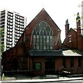
Holy Family Catholic Church - Green Lane
Image: © Betty Longbottom
Taken: 21 May 2007
0.00 miles
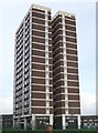
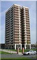
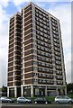
3
High Living
The Clyde Grange tower block, Leeds.
Image: © Ian S
Taken: 24 Jul 2010
0.01 miles
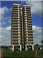
4
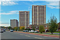
Flats in Wellington Road
Clyde Court and Clyde Grange, high rise buildings in Wellington Road, in the New Wortley part of Leeds.
Image: © Mary and Angus Hogg
Taken: 19 Oct 2018
0.01 miles
9

Clyde Court, Wortley
A tower block, viewed here from Copley Yard.
Image: © Stephen Craven
Taken: 16 Jan 2022
0.04 miles