IMAGES TAKEN NEAR TO
School Mews, LEEDS, LS12 1TG
Introduction
This page details the photographs taken nearby to School Mews, LS12 1TG by members of the Geograph project.
The Geograph project started in 2005 with the aim of publishing, organising and preserving representative images for every square kilometre of Great Britain, Ireland and the Isle of Man.

There are currently over 7.5m images from over14,400 individuals and you can help contribute to the project by visiting https://www.geograph.org.uk
Image Map
Images are licensed for reuse under creativecommons.org/licenses/by-sa/2.0
Notes
- Clicking on the map will re-center to the selected point.
- The higher the marker number, the further away the image location is from the centre of the postcode.
Image Listing (533 Images Found)
Images are licensed for reuse under creativecommons.org/licenses/by-sa/2.0
Image
Details
Distance
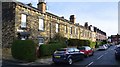
1
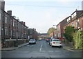
Laurel Place - Brooklyn Terrace, Armley
Image: © Betty Longbottom
Taken: 3 Nov 2008
0.03 miles
3
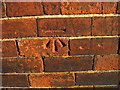
Ordnance Survey Cut Mark on wall of 1 Laurel Place, Armley
This can be found on the gable end wall of the house.
Image: © Peter Wood
Taken: 14 Jan 2012
0.03 miles
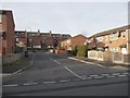
6
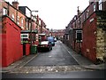
Laurel Street - Chapel Lane, Armley
Image: © Betty Longbottom
Taken: 4 Nov 2008
0.04 miles
9
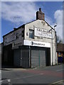
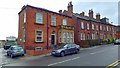
Stradbrokes Solicitors - Stocks Hill
Image: © Betty Longbottom
Taken: 4 Apr 2010
0.05 miles
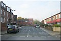
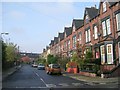
10
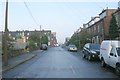
Brooklyn Terrace - Church Road, Armley
Image: © Betty Longbottom
Taken: 3 Nov 2008
0.05 miles