IMAGES TAKEN NEAR TO
Whitehall, LEEDS, LS12 1EQ
Introduction
This page details the photographs taken nearby to Whitehall, LS12 1EQ by members of the Geograph project.
The Geograph project started in 2005 with the aim of publishing, organising and preserving representative images for every square kilometre of Great Britain, Ireland and the Isle of Man.

There are currently over 7.5m images from over14,400 individuals and you can help contribute to the project by visiting https://www.geograph.org.uk
Image Map
Images are licensed for reuse under creativecommons.org/licenses/by-sa/2.0
Notes
- Clicking on the map will re-center to the selected point.
- The higher the marker number, the further away the image location is from the centre of the postcode.
Image Listing (751 Images Found)
Images are licensed for reuse under creativecommons.org/licenses/by-sa/2.0
Image
Details
Distance
1
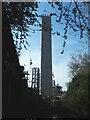
Another tower block going up in Leeds
The concrete core of another 21-storey tower, one of several being erected on former railway land off Graingers Way, west of the Leeds and Liverpool Canal
Image: © Stephen Craven
Taken: 31 Mar 2021
0.00 miles
2
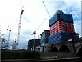
Monksbridge development in progress
A 21-storey tower, one of several being erected on former railway land off Graingers Way, west of the Leeds and Liverpool Canal. See Image for the state of progress about a year earlier.
Image: © Stephen Craven
Taken: 17 Mar 2022
0.01 miles
3
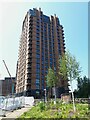
Tower block adjacent to Central Viaduct
Several new blocks, I presume residential rather than commercial, have been or are being constructed adjacent to the converted viaduct.
Image: © Stephen Craven
Taken: 9 Jun 2023
0.01 miles
9
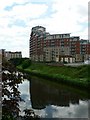
City Island and the River Aire, Leeds
City Island apartment block, and the River Aire, viewed from the bridge on the slip road from Wellington Street to the A58 Inner Ring Road.
Image: © Rich Tea
Taken: 31 May 2006
0.02 miles
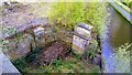
10
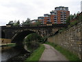
Leeds & Liverpool Canal bridge 225F
The old viaduct that used to take trains to Leeds Central station
Image: © John Slater
Taken: 12 Jun 2012
0.02 miles