IMAGES TAKEN NEAR TO
Driver Street, LEEDS, LS12 1EB
Introduction
This page details the photographs taken nearby to Driver Street, LS12 1EB by members of the Geograph project.
The Geograph project started in 2005 with the aim of publishing, organising and preserving representative images for every square kilometre of Great Britain, Ireland and the Isle of Man.

There are currently over 7.5m images from over14,400 individuals and you can help contribute to the project by visiting https://www.geograph.org.uk
Image Map
Images are licensed for reuse under creativecommons.org/licenses/by-sa/2.0
Notes
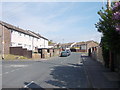
- Clicking on the map will re-center to the selected point.
- The higher the marker number, the further away the image location is from the centre of the postcode.
Image Listing (226 Images Found)
Images are licensed for reuse under creativecommons.org/licenses/by-sa/2.0
Image
Details
Distance
2
Site of the New Wortley gas holder
The gas holder Image was erected in the 1950s on the site of former terraced housing known as Duce Square, but was demolished in 2021. I don't know if there is already a plan for the redevelopment of the site.
Image: © Stephen Craven
Taken: 23 Oct 2021
0.03 miles
3
New Wortley gasholder
The gasholder is a local landmark adjacent to the Armley Gyratory roundabout. Viewed from a footbridge over the A643, see Image for a wider view.
Image: © Stephen Craven
Taken: 28 Jul 2016
0.04 miles
4
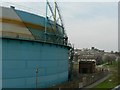
Gas holder, New Wortley
At the corner of the Armley Gyratory and Wellington Road. The tower on the horizon is part of HM Prison Leeds (better known as Armley Jail).
Image: © Rich Tea
Taken: 2 Apr 2007
0.05 miles
6
Wellington Road - viewed from Footbridge
Image: © Betty Longbottom
Taken: 7 May 2012
0.05 miles
7

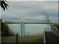
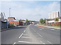
A643 at New Wortley
Looking south from a footbridge over the A643, which at this point is a separated dual carriageway, known locally as the "Ingram Distributor" (as it is roughly parallel to the older Ingram Road which is now closed to through traffic). The bridge in the photo carries the railway line from Bradford Interchange to Leeds.
Image: © Stephen Craven
Taken: 28 Jul 2016
0.06 miles
8

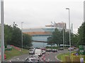
Entering the Armley Gyratory
The "gyratory" is a large roundabout on the south-western approach to Leeds, with traffic light control, notorious both for congestion at peak times (which in the evening tails back into the city centre) and for being intimidating to those not familiar with the lane arrangement. Even as an experienced city cyclist I would not wish to ride round it. Fortunately there is a pedestrian / cycle bridge over the southern approach road, from which this photo is taken.
Image: © Stephen Craven
Taken: 28 Jul 2016
0.06 miles
9
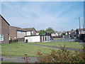
Bruce Lawn - viewed from Wellington Road
Image: © Betty Longbottom
Taken: 7 May 2012
0.06 miles
10
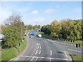
Armley Gyratory - viewed from Footbridge
Image: © Betty Longbottom
Taken: 7 May 2012
0.07 miles