IMAGES TAKEN NEAR TO
Milnes Street, LEEDS, LS12 1DY
Introduction
This page details the photographs taken nearby to Milnes Street, LS12 1DY by members of the Geograph project.
The Geograph project started in 2005 with the aim of publishing, organising and preserving representative images for every square kilometre of Great Britain, Ireland and the Isle of Man.

There are currently over 7.5m images from over14,400 individuals and you can help contribute to the project by visiting https://www.geograph.org.uk
Image Map
Images are licensed for reuse under creativecommons.org/licenses/by-sa/2.0
Notes
- Clicking on the map will re-center to the selected point.
- The higher the marker number, the further away the image location is from the centre of the postcode.
Image Listing (210 Images Found)
Images are licensed for reuse under creativecommons.org/licenses/by-sa/2.0
Image
Details
Distance
4
Former School House - Kildare Terrace, Whitehall Road
Image: © Betty Longbottom
Taken: 28 Apr 2008
0.06 miles
5
Site of the New Wortley gas holder
The gas holder Image was erected in the 1950s on the site of former terraced housing known as Duce Square, but was demolished in 2021. I don't know if there is already a plan for the redevelopment of the site.
Image: © Stephen Craven
Taken: 23 Oct 2021
0.08 miles
6
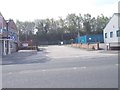
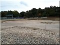
Former school playground, Gelderd Road, Leeds
For the school building to the right, see Image
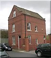
The former caretaker's house in the distance Image is separately listed as 'a good example of the type of house provided with all Board Schools'.
Image: © Stephen Craven
Taken: 6 Apr 2024
0.08 miles
8
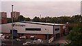
Widd Signs, New Wortley
One of many industrial units in this corner of Leeds, with easy access to the motorway network. Seen from the footbridge over the A643 Image
Image: © Stephen Craven
Taken: 19 May 2016
0.08 miles
9
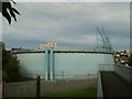
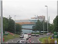
New Wortley gasholder
The gasholder is a local landmark adjacent to the Armley Gyratory roundabout. Viewed from a footbridge over the A643, see Image for a wider view.
Image: © Stephen Craven
Taken: 28 Jul 2016
0.08 miles
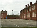
10

Adams Court, Gelderd Road, Leeds (1)
Originally a typical urban Victorian Board School (Whitehall Road school), built in 1884, architect Richard Adams. The grade II listing (list entry 1375031) refers to it as the 'former Jacob Kramer College' but it had been more recently used by Leeds CIty Council as a children's centre. It has recently (2024) been auctioned off to a new owner but I don't know who this is.
Image: © Stephen Craven
Taken: 6 Apr 2024
0.09 miles