IMAGES TAKEN NEAR TO
Graingers Way, Roundhouse Business Park, LEEDS, LS12 1AH
Introduction
This page details the photographs taken nearby to Graingers Way, Roundhouse Business Park, LS12 1AH by members of the Geograph project.
The Geograph project started in 2005 with the aim of publishing, organising and preserving representative images for every square kilometre of Great Britain, Ireland and the Isle of Man.

There are currently over 7.5m images from over14,400 individuals and you can help contribute to the project by visiting https://www.geograph.org.uk
Image Map
Images are licensed for reuse under creativecommons.org/licenses/by-sa/2.0
Notes
- Clicking on the map will re-center to the selected point.
- The higher the marker number, the further away the image location is from the centre of the postcode.
Image Listing (670 Images Found)
Images are licensed for reuse under creativecommons.org/licenses/by-sa/2.0
Image
Details
Distance
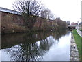
1

Leeds & Liverpool Canal
The canal and new buildings viewed from the A58 in central Leeds.
Image: © Mary and Angus Hogg
Taken: 19 Oct 2018
0.01 miles

3
Anti-lockdown protest sticker by the Leeds - Liverpool Canal
This sticker reads "THEY HAVE SUCKED ALL THE JOY OUT OF LIFE!" and is formatted to resemble official communications from the government during the Coronavirus pandemic.
Image: © Mark Anderson
Taken: 2 Dec 2020
0.02 miles
4
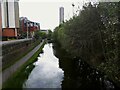
Canal east of Wellington Road bridge
Compare Image taken in 2014, showing the City Island buildings to the left already present then; a further high rise development is now in progress in the distance. Decades ago (in the age of steam) there were railway works either side of the canal here, which must have made it a very polluted environment.
Image: © Stephen Craven
Taken: 13 May 2021
0.02 miles
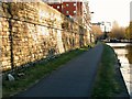
5
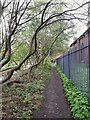
Path alongside the canal east of Wellington Road bridge
This is not the official towpath on the north side, but an unofficial path on the south side of the canal between Wellington Road bridge and St Ann'e Ing lock.
Image: © Stephen Craven
Taken: 13 May 2021
0.02 miles
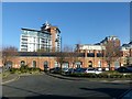
6
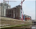
Construction continues at City Island
More apartments at City Island. Pictured from the south side of the Leeds & Liverpool Canal, standing just by the buttress of the bridge that carries Wellington Road over the canal.
Image: © Rich Tea
Taken: 13 Apr 2007
0.02 miles
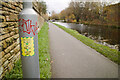
7
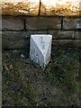
Canal milepost, Leeds and Liverpool Canal
One of a series of replica mileposts installed along the Leeds end of the Canal in 1997. See http://www.geograph.org.uk/photo/5627606 for location.
Image: © Alan Murray-Rust
Taken: 11 Dec 2017
0.02 miles
9
Leeds and Liverpool Canal towpath
St Ann's Ings Lock in the background. The towpath forms part of Sustrans route 66.
Note the milepost http://www.geograph.org.uk/photo/5627601 at the left hand side.
Image: © Alan Murray-Rust
Taken: 11 Dec 2017
0.02 miles
10
Former railway workshops, Grainger's Way
Workshops associated with the neighbouring Roundhouse locomotive shed. Built c.1845 by Thomas Grainger for the Leeds and Thirsk Railway. In recent years the building has been restored with later additions being removed to reveal the original form of the building. The right hand end of the building with its chimneys was almost certainly a forge shop. Listed Grade II. This blue plaque http://www.geograph.org.uk/photo/5627576 explains the importance of this building and its neighbours.
Image: © Alan Murray-Rust
Taken: 11 Dec 2017
0.02 miles