IMAGES TAKEN NEAR TO
Jenkinson Lawn, LEEDS, LS11 9QX
Introduction
This page details the photographs taken nearby to Jenkinson Lawn, LS11 9QX by members of the Geograph project.
The Geograph project started in 2005 with the aim of publishing, organising and preserving representative images for every square kilometre of Great Britain, Ireland and the Isle of Man.

There are currently over 7.5m images from over14,400 individuals and you can help contribute to the project by visiting https://www.geograph.org.uk
Image Map (Loading...)


Getting Data...Please wait
Leaflet Map data © OpenStreetMap
Images are licensed for reuse under creativecommons.org/licenses/by-sa/2.0
Notes
- Clicking on the map will re-center to the selected point.
- The higher the marker number, the further away the image location is from the centre of the postcode.
Image Listing (280 Images Found)
Images are licensed for reuse under creativecommons.org/licenses/by-sa/2.0
Image
Details
Distance
1
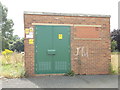
Electricity Substation No 2851 - off Jenkinson Close
Image: © Betty Longbottom
Taken: 14 Aug 2012
0.00 miles
2
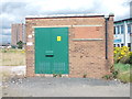
Electricity Substation No 2850 - off Jenkinson Close
Image: © Betty Longbottom
Taken: 14 Aug 2012
0.00 miles
3
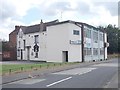
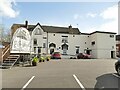
Holbeck Moor Working Men's Club - off Jenkinson Close
Image: © Betty Longbottom
Taken: 14 Aug 2012
0.01 miles
4
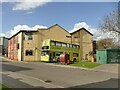
Bus round the back of Holbeck WMC
The bus bearing the name 'Cultural Community College' belongs to the Slung Low Theatre Company, based at the Holbeck Working Men's Club (the building behind it).
Image: © Stephen Craven
Taken: 2 Apr 2022
0.01 miles
5
Holbeck WMC
Holbeck Working Men's Club claims to be the oldest of its kind, the building dating from 1878.
Image: © Stephen Craven
Taken: 2 Apr 2022
0.02 miles
6
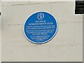
Holbeck WMC - blue plaque
The Leeds Civic Trust plaque records the origins of Holbeck Working Men's Club in 1871, which claims to be the oldest of its kind, although the building itself only dates from 1878.
Image: © Stephen Craven
Taken: 2 Apr 2022
0.02 miles
7
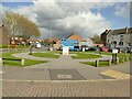
Green space on Jenkinson Close
There is a plaque at the centre of this small circular green space, explaining the names of the roads in the development.
Image: © Stephen Craven
Taken: 2 Apr 2022
0.03 miles
8
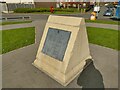
Plaque from the Gaitskell flats
The plaque on this side of the stone at the centre of a small circular green Image came from the previous, 1960s development of five tower blocks named after Hugh Gaitskell, MP for Leeds South from 1945 to 1963. The flats were demolished in 2010 and replaced with more low-rise housing.
Image: © Stephen Craven
Taken: 2 Apr 2022
0.03 miles
9
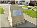
Plaque on Jenkinson Close
The plaque on this side of the stone at the centre of a small circular green Image explains that this and other nearby roads developed c.2010-2018 are named after the Revd Charles Jenkinson, Vicar of the two nearby churches of St John & St Barnabas from 1927-1938 (at which time they were demolished) and city councillor until 1949, being Chairman of the Housing Committee for part of that time.
The plaque on the other side relates to a previous generation of housing on the site Image
Image: © Stephen Craven
Taken: 2 Apr 2022
0.03 miles
10
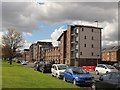
New build properties, Holbeck Moor Road
This new social housing was built in 2014/15 by Sustainable Communities for Leeds (sc4L) in partnership with Leeds City Council. See Image for the previous flats on the site.
Image: © Stephen Craven
Taken: 30 Apr 2016
0.03 miles