IMAGES TAKEN NEAR TO
Fairfax Road, LEEDS, LS11 8SY
Introduction
This page details the photographs taken nearby to Fairfax Road, LS11 8SY by members of the Geograph project.
The Geograph project started in 2005 with the aim of publishing, organising and preserving representative images for every square kilometre of Great Britain, Ireland and the Isle of Man.

There are currently over 7.5m images from over14,400 individuals and you can help contribute to the project by visiting https://www.geograph.org.uk
Image Map
Images are licensed for reuse under creativecommons.org/licenses/by-sa/2.0
Notes
- Clicking on the map will re-center to the selected point.
- The higher the marker number, the further away the image location is from the centre of the postcode.
Image Listing (234 Images Found)
Images are licensed for reuse under creativecommons.org/licenses/by-sa/2.0
Image
Details
Distance
1
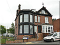
1 Fairfax Road
An imposing house on the corner of the road.
Image: © Stephen Craven
Taken: 15 Aug 2020
0.02 miles
2
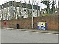
Leeds United box, Cemetery Road, Beeston Hill
There are now many utility cabinets around Leeds painted in the colours of the city's leading football team. To the left is a bus stop on the 86 route (Middleton to Rodley).
Image: © Stephen Craven
Taken: 2 Apr 2022
0.03 miles
3
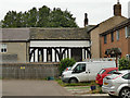
The Manor House and Cad Beeston
Tucked away round the back of some modern housing, it seems other contributors have missed this gem, and I was only alerted to it by an information board in the nearby cemetery. The timber-framed section is what remains of the old medieval Manor House of Beeston, dating from c.1421, restored 1985 and grade II* listed (entry 1255940); the section to the right is a 19th century house known as Cad Beeston, grade II listed (entry 1255939) and the section to the left is a 19th century extension.
Image: © Stephen Craven
Taken: 15 Aug 2020
0.03 miles
4
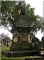
Monument to Henry Rowland Marsden - Holbeck Cemetery
This is a Grade II listed monument. Henry Marsden was born 1823 and died 1876. He was mayor of Leeds 1874-75.
Image: © Betty Longbottom
Taken: 14 Sep 2008
0.04 miles
5
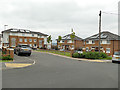
Fairfax Crescent
A recent housing development, apparently on the site of earlier housing occupying the same space.
Image: © Stephen Craven
Taken: 15 Aug 2020
0.04 miles
6
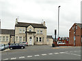
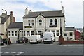
The Imperial, Cemetery Road, Holbeck
A former hotel and pub, described in a CAMRA guide to Leeds pubs published in 1993 as 'a one-roomed pub with a strong Irish feel.' It looks as though it may now be a bed-and-breakfast establishment or similar. See Image for a rear view.
Image: © Stephen Craven
Taken: 15 Aug 2020
0.04 miles
7
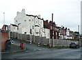
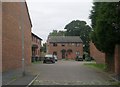
The back of the Imperial Hotel, Holbeck, Leeds
This building looked very impressive from Malvern Road, so I came up to investigate. It is shown on the 1893 1:2500 map.
Image: © Humphrey Bolton
Taken: 8 Jun 2019
0.04 miles
8
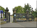
Gates of Holbeck cemetery
The grade II listing (list entry 1375431) covers the gate piers, gates and flanking walls.
Image: © Stephen Craven
Taken: 15 Aug 2020
0.05 miles
9
Imperial - Cemetery Road, Beeston Hill
Image: © Betty Longbottom
Taken: 26 May 2008
0.05 miles
10
Cad Beeston Mews - Temple Crescent
Image: © Betty Longbottom
Taken: 14 Sep 2008
0.06 miles