IMAGES TAKEN NEAR TO
LS11 6ES
Introduction
This page details the photographs taken nearby to LS11 6ES by members of the Geograph project.
The Geograph project started in 2005 with the aim of publishing, organising and preserving representative images for every square kilometre of Great Britain, Ireland and the Isle of Man.

There are currently over 7.5m images from over14,400 individuals and you can help contribute to the project by visiting https://www.geograph.org.uk
Image Map
Images are licensed for reuse under creativecommons.org/licenses/by-sa/2.0
Notes
- Clicking on the map will re-center to the selected point.
- The higher the marker number, the further away the image location is from the centre of the postcode.
Image Listing (243 Images Found)
Images are licensed for reuse under creativecommons.org/licenses/by-sa/2.0
Image
Details
Distance
1
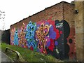
Mural near Dewsbury Road Community Hub
The mural on the back wall of the Conservative Club consists of six mice in the style of Walt Disney, but credited to Fat Cap Sprays.
Image: © Stephen Craven
Taken: 27 Jan 2024
0.01 miles
2
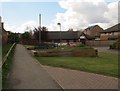
Path from Dewsbury Road to Bismarck Street
Old maps show this path running along the east side of the allotments, which are still present Image and coming out on Dewsbury Road opposite Burton Road; it has been realigned in recent redevelopment to come out here about 70m further north opposite Burton Avenue.
Image: © Stephen Craven
Taken: 30 Apr 2016
0.01 miles
3
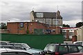
West Hunslet Conservative Club - Dewsbury Road
Image: © Betty Longbottom
Taken: 18 Sep 2007
0.03 miles
4
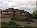
Dewsbury Road One Stop Centre
No point stopping by on a Saturday afternoon, it looks closed.
Image: © Stephen Craven
Taken: 30 Apr 2016
0.04 miles
5
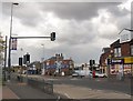
Dewsbury Road - puffin crossing
Located outside the One Stop Centre Image The repeater light above the traffic lane is a Continental practice that seems to have gained popularity in the UK in recent years.
Image: © Stephen Craven
Taken: 30 Apr 2016
0.04 miles
6
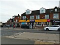
Dewsbury Road shops
A short parade of shops on the east side of the road including a convenience store with sub post office, hairstylist and solicitor (there are a few other units just out of shot to the right).
Image: © Stephen Craven
Taken: 30 Apr 2016
0.05 miles
7
Post Office/shop on Dewsbury Road at Burton Avenue junction
There is an OS benchmark Image on the left hand side of the post office near its front corner
Image: © Roger Templeman
Taken: 18 Jul 2016
0.05 miles
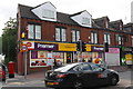
8
Dewsbury Road Community Hub
In 2016 this was the One Stop Centre Image but the services provided are probably much the same.
Image: © Stephen Craven
Taken: 27 Jan 2024
0.05 miles
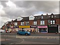
9
Dewsbury Road post office and Premier stores
Apart from the signage above the shop and the name of the hair salon next door, not much has changed since my 2016 view Image But pavement parking as seen here has become a much more common practice in recent years; it is legal in most of England but that is currently under review.
Image: © Stephen Craven
Taken: 27 Jan 2024
0.05 miles
10
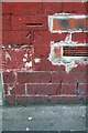
Benchmark on #163 Dewsbury Road
Ordnance Survey cut mark benchmark described on the Bench Mark Database at http://www.bench-marks.org.uk/bm77169
Image: © Roger Templeman
Taken: 18 Jul 2016
0.05 miles