IMAGES TAKEN NEAR TO
Aire Quay, LEEDS, LS10 1GA
Introduction
This page details the photographs taken nearby to Aire Quay, LS10 1GA by members of the Geograph project.
The Geograph project started in 2005 with the aim of publishing, organising and preserving representative images for every square kilometre of Great Britain, Ireland and the Isle of Man.

There are currently over 7.5m images from over14,400 individuals and you can help contribute to the project by visiting https://www.geograph.org.uk
Image Map
Images are licensed for reuse under creativecommons.org/licenses/by-sa/2.0
Notes
- Clicking on the map will re-center to the selected point.
- The higher the marker number, the further away the image location is from the centre of the postcode.
Image Listing (133 Images Found)
Images are licensed for reuse under creativecommons.org/licenses/by-sa/2.0
Image
Details
Distance
2
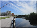
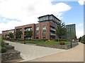
Aire Quay
Looking along the River Aire as it passes modern flats.
Image: © DS Pugh
Taken: 26 May 2023
0.03 miles
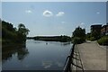
3
The western end of Knostrop Cut
The channel on the right, known as Knostrop Cut is a canal channel which runs adjacent to the River Aire.
Image: © Graham Robson
Taken: 3 Aug 2015
0.04 miles
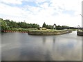
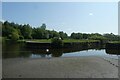
4
Three ways, but only one navigable
From left to right: an unnavigable stretch of the River Aire, Knostrop Flood Lock leading to a navigable cut, and the basin of the former Leeds oil terminal.
Image: © Christine Johnstone
Taken: 15 Jan 2012
0.04 miles
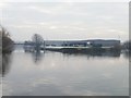
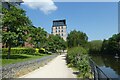
5
Riverside apartments, Leeds
Downstream of the city centre along the River Aire are located these modern apartment buildings with well tended green space.
Image: © Graham Robson
Taken: 3 Aug 2015
0.04 miles
6

Short offshoot of the River Aire in Leeds
Image: © Mat Fascione
Taken: 4 Aug 2017
0.05 miles
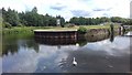
7
Swan near a lock entrance
This lock is no longer used.
Image: © DS Pugh
Taken: 26 May 2023
0.05 miles
8
Riverside path at Aire Quay
Looking along the bank of the River Aire on the west side.
Image: © DS Pugh
Taken: 26 May 2023
0.06 miles
9

River Aire looking towards Atkinson Hill
New buildings not shown on latest map beyond flood dock and lock on Aire and Calder Navigation.
Image: © Chris Morgan
Taken: 8 Mar 2013
0.06 miles
10
Looking towards Knostrop Cut from South bank
Image: © Darren Haddock
Taken: 12 Jul 2019
0.06 miles