IMAGES TAKEN NEAR TO
Belchford, HORNCASTLE, LN9 6LT
Introduction
This page details the photographs taken nearby to LN9 6LT by members of the Geograph project.
The Geograph project started in 2005 with the aim of publishing, organising and preserving representative images for every square kilometre of Great Britain, Ireland and the Isle of Man.

There are currently over 7.5m images from over14,400 individuals and you can help contribute to the project by visiting https://www.geograph.org.uk
Image Map
Images are licensed for reuse under creativecommons.org/licenses/by-sa/2.0
Notes
- Clicking on the map will re-center to the selected point.
- The higher the marker number, the further away the image location is from the centre of the postcode.
Image Listing (7 Images Found)
Images are licensed for reuse under creativecommons.org/licenses/by-sa/2.0
Image
Details
Distance
1

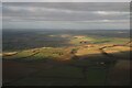
Ings Farm and Bluestone Heath Road: aerial 2014
From the SW. The Bluestone Heath Road runs across the centre.
The bump on the right at the end of the line of trees is Rosin Hill, about 125m high. This can be seen more clearly in Image, which is another shot of this area, and of Rosin Hill, from the NW.
The Bluestone Heath Road runs along the top of the Lincolnshire Wolds, thus affording some far-reaching views. To the East (top) the views are of the Marshes and Coastal Strip, and now also of enormous offshore windfarms. To the West (behind the camera) the Lincoln "Cliff" (and Cathedral) and the Trent Valley are visible from it.
Image: © Chris
Taken: 2 Jan 2014
0.05 miles
3
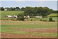
Ings Farm
This farm is sheltering underneath the chalk ridge of the Wolds.
Image: © Tony Atkin
Taken: 9 Sep 2006
0.07 miles
4
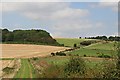
Ings Lane
This is a view of the northern end of the lane where it climbs the chalk ridge to join the Bluestone Heath Road at the top of the hill.
Image: © Tony Atkin
Taken: 9 Sep 2006
0.11 miles
5
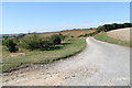
Farm Track off Bluestone Heath Lane
This is called Ings Lane, and runs down to Belchford.
Image: © J.Hannan-Briggs
Taken: 8 Sep 2013
0.14 miles
6

Crop field beside Belt Plantation
Off Bluestone Heath Road.
Image: © JThomas
Taken: 4 Jun 2020
0.17 miles
7
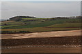
Wolds escarpment from Belchford Hill
Line of seagulls on the newly ploughed land. First outcrop on the right is Rosin Hill, with Ings Farm and Grove Plantation (above Scamblesby Grove) behind.
Image: © Chris
Taken: 15 Mar 2014
0.21 miles