IMAGES TAKEN NEAR TO
Bryant Close, HORNCASTLE, LN9 6EH
Introduction
This page details the photographs taken nearby to Bryant Close, LN9 6EH by members of the Geograph project.
The Geograph project started in 2005 with the aim of publishing, organising and preserving representative images for every square kilometre of Great Britain, Ireland and the Isle of Man.

There are currently over 7.5m images from over14,400 individuals and you can help contribute to the project by visiting https://www.geograph.org.uk
Image Map
Images are licensed for reuse under creativecommons.org/licenses/by-sa/2.0
Notes
- Clicking on the map will re-center to the selected point.
- The higher the marker number, the further away the image location is from the centre of the postcode.
Image Listing (526 Images Found)
Images are licensed for reuse under creativecommons.org/licenses/by-sa/2.0
Image
Details
Distance
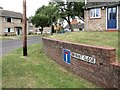
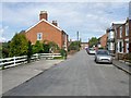
1
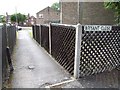
Bryant Close, Horncastle
A walkway between South Street and Croft Street. The close contains some sheltered housing. The South Street end - http://www.geograph.org.uk/photo/1411854
Image: © Dave Hitchborne
Taken: 18 Jul 2009
0.01 miles
2
Bryant Close, Horncastle
I just took a discrete photograph into the close as it's all sheltered housing and retirement homes for the elderly, of which I am one, but I don't live here.
I did attract attention and was asked by an elderly gentleman if I was there to photograph the Town Hall. Before I could answer, I was told what an eyesore it was. So that's one opinion. There again, most places look untidy when they are boarded up.
His wife gave him the, "What are you on about", look, when he told me the old Drill Hall was once the Town Hall. Which it wasn't.
The housing in the close was built in 1969.
Image: © Dave Hitchborne
Taken: 18 Jul 2009
0.02 miles
3
Croft Street, Horncastle
Looking from Bryant Close to Queen Street. The Close is relatively quiet, there being no through traffic. There is a walkway to South Street from this end of the street, which makes the swimming baths more accessible.
Image: © Dave Hitchborne
Taken: 18 Jul 2009
0.02 miles
4
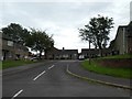
Bryant Close, Horncastle
A small estate of houses and bungalows
Image: © David Smith
Taken: 19 Sep 2018
0.02 miles
5
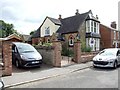
Croft Street, Horncastle
Romney House - The description given by Robert Bell & Company, is, "This residence was once a former church..." Well, actually, this still is a former church, so anyone looking for this to be a consecrated building, will be disappointed.
Image: © Dave Hitchborne
Taken: 18 Jul 2009
0.02 miles
6
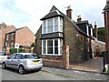
Romney House, Horncastle
This house on Croft Street was once a church, but the Estate Agents may lead you to believe it still is. Just a mistake in the wording.
Image: © Dave Hitchborne
Taken: 18 Jul 2009
0.02 miles
7
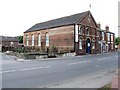
South Street, Horncastle
The Drill Hall Antiques Centre was a school, a drill hall, a coach works, an agricultural store and Whizzkids, a play centre.
When Danby & Cheseldine used the place for building horse carriages, I wonder if they upholstered the seats with pig skin as there are pig pens adjacent to the building. The name DANBY & CHESELDINE COACH WORKS still exists, painted on the brickwork outside - http://www.geograph.org.uk/photo/1408987 http://www.geograph.org.uk/photo/1408937 the rear http://www.geograph.org.uk/photo/1408981
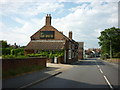
The building at centre was the Castle Inn.
Image: © Dave Hitchborne
Taken: 18 Jul 2009
0.04 miles
8
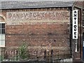
South Street, Horncastle
The writing on the wall is, DANBY & CHESELDINE, whose profession was coach building - the horse and carriage type. This building was built as a school, around 1900. It was then used as a drill hall, coach works, agricultural store, play centre and finally antique centre.
Image: © Dave Hitchborne
Taken: 18 Jul 2009
0.04 miles