IMAGES TAKEN NEAR TO
The Wong, HORNCASTLE, LN9 6EA
Introduction
This page details the photographs taken nearby to The Wong, LN9 6EA by members of the Geograph project.
The Geograph project started in 2005 with the aim of publishing, organising and preserving representative images for every square kilometre of Great Britain, Ireland and the Isle of Man.

There are currently over 7.5m images from over14,400 individuals and you can help contribute to the project by visiting https://www.geograph.org.uk
Image Map
Images are licensed for reuse under creativecommons.org/licenses/by-sa/2.0
Notes
- Clicking on the map will re-center to the selected point.
- The higher the marker number, the further away the image location is from the centre of the postcode.
Image Listing (557 Images Found)
Images are licensed for reuse under creativecommons.org/licenses/by-sa/2.0
Image
Details
Distance
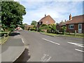
1
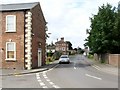
Cagthorpe, Horncastle
Cagthorpe, at the end of which is the former Cagthorpe Secondary Modern School, where my wife attended many years ago. It is now the Youth Centre.
Beyond that is the Town Centre, which is reached by crossing over the A158, that runs over the River Waring.
Image: © Dave Hitchborne
Taken: 18 Jul 2009
0.03 miles
2
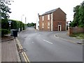
The Wong, Horncastle
The junction of The Wong with Cagthorpe. Cagthorpe, to the right, leads to the playing fields and car park, the River Waring, the A158 and the Town Centre. The Wong also leads to the playing fields, but better on foot.
Image: © Dave Hitchborne
Taken: 18 Jul 2009
0.03 miles
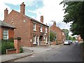
3
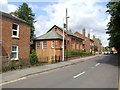
The Wong, Horncastle
A view of The Wong, which includes the former Courthouse, and the Police Station.
Image: © Dave Hitchborne
Taken: 18 Jul 2009
0.05 miles
4
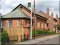
Former Courthouse, Horncastle
As can be seen, the building stands next door to the Police Station. A poster in the window advertises, "Summer Fayre Here".
Image: © Dave Hitchborne
Taken: 18 Jul 2009
0.05 miles
5
Cagthorpe, Horncastle
Looking along Cagthorpe towards South Street, the A153. A quiet corner of Horncastle.
Image: © Dave Hitchborne
Taken: 18 Jul 2009
0.05 miles
6
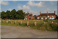
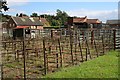
Horncastle former cattle market: a derelict patch of weeds
This is the area once occupied by Horncastle's historic cattle market as portrayed in Dave Hitchborne's (2009) and Tony Atkin's (2006) photos: Image; Image; Image; Image; Image
All that remains now is the small group of sheep pens in photos Image; Image; Image
The Council declared the pens unsafe, and demolished them. It has got its way so far, and it remains to be seen if it will manage to build itself some new offices on this fiercely defended piece of common land.
After all, the Council knows how these things work: first create a weedy eye-sore, then suggest that some offices would be an improvement!
Image: © Chris
Taken: 12 Aug 2012
0.06 miles
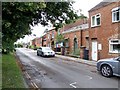
7
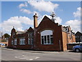
The Wong, Horncastle
Horncastle Police Station. It was built in 1853, at a cost of £500. It had four cells, for 12 prisoners, and a residence for a superintendent and constable. The small entranceway leads to a car park behind the former Courthouse.
Image: © Dave Hitchborne
Taken: 18 Jul 2009
0.06 miles
8
The Wong, Horncastle
Horncastle Police Station was built in 1853, at a cost of £500. It had four cells, for 12 prisoners, and a residence for a superintendent and constable.
Image: © Dave Hitchborne
Taken: 18 Jul 2009
0.07 miles
9
The Remains of the Livestock Market on Horncastle Wong
At the time of writing these cattle and sheep pens which have been slowly rusting away since the closure of the market occupy just about the most controversial piece of land in Horncastle. The local council wants to build new council offices on this land, a proposal which sees furious opposition from many local residents. These stalls occupy part of an area of land known as "The Wong". Some argue that as The Wong is ancient common land it should not be built on. The word "wong" is an rarely used term meaning 'common land' although it was in more regular usage about 1000 years ago.
Image: © Tony Atkin
Taken: 7 Sep 2006
0.08 miles
10
Horncastle Youth Centre
The building carries a cut bench mark on the nearest angle. See http://www.geograph.org.uk/photo/4352233 for a close-up and http://www.bench-marks.org.uk/bm64309 for details of the mark.
Image: © Brian Westlake
Taken: 13 Apr 2013
0.08 miles