IMAGES TAKEN NEAR TO
High Street, HORNCASTLE, LN9 5PD
Introduction
This page details the photographs taken nearby to High Street, LN9 5PD by members of the Geograph project.
The Geograph project started in 2005 with the aim of publishing, organising and preserving representative images for every square kilometre of Great Britain, Ireland and the Isle of Man.

There are currently over 7.5m images from over14,400 individuals and you can help contribute to the project by visiting https://www.geograph.org.uk
Image Map
Images are licensed for reuse under creativecommons.org/licenses/by-sa/2.0
Notes
- Clicking on the map will re-center to the selected point.
- The higher the marker number, the further away the image location is from the centre of the postcode.
Image Listing (10 Images Found)
Images are licensed for reuse under creativecommons.org/licenses/by-sa/2.0
Image
Details
Distance
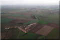
1
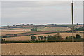
Looking east across the Wolds from the footpath to Stourton
Watermill Farm is just visible left of the telegraph pole.
Image: © Chris
Taken: 21 Aug 2013
0.01 miles
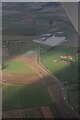
2
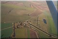
Water Mill and Horncastle's new flood defences near Watermill Farm, Hemingby: aerial 2018 (1)
Flood defence area in Image
Image: © Chris
Taken: 18 Nov 2018
0.01 miles
3
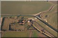
Water Mill and Horncastle's new flood defences near Watermill Farm, Hemingby: aerial 2018 (2)
Image: © Chris
Taken: 18 Nov 2018
0.03 miles

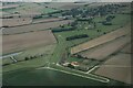
6

Horncastle's new flood defences near Watermill Farm, Hemingby: aerial October 2015
By the River Bain. See http://www.horncastlenews.co.uk/news/local/hemingby-is-site-for-new-flood-defences-1-6735495
The weather may be dull down there but the October evening sun is still shining up here, hence the warm orange glow on the wing spar.
See later shot (end of November): Image
Image: © Chris
Taken: 2 Oct 2015
0.14 miles
7
Horncastle's new flood defences near Watermill Farm, Hemingby: aerial November 2015
On the River Bain. See: http://www.horncastlenews.co.uk/news/local/hemingby-is-site-for-new-flood-defences-1-6735495
See also earlier shot (October) Image
For finished picture see Image
Image: © Chris
Taken: 26 Nov 2015
0.14 miles
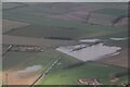
8
Horncastle's Flood Alleviation Scheme at Watermill Farm, Hemingby: aerial 2024 (1)
On the River Bain.
See Image
The £8.8m flood alleviation scheme is based on farmland close to Watermill Farm. It features a 720-metre long embankment five metres high with a 4m wide ‘crest’.
The project was a multi-agency scheme which involved the Environment Agency, East Lindsey District Council, Lincolnshire County Council, Horncastle Town Council, the Witham Drainage Board and Anglian Water.
The River Bain is channelled through the embankment, and in times of heavy rain, potential flood water is held back and allowed to create new holding lakes. Once the heavy rain has stopped - and the threat of flooding receded - the water is allowed to drain back into the river.
The scheme was completed in 2017, but has had an eventful existence. It failed dramatically following Storm Babet in October 2023, when the gate into the holding lake failed to open. The latest theory, however, is that this was a one in a thousand year flood, which it would not have been able to compensate for.
Finally it seemed to have saved the day at the beginning of January 2024, and the reservoir, shown here, is partly full. Despite high river levels, the water in Horncastle seemed to have covered only a footpath alongside a park - people were able to find another way to Tesco's!
Image: © Chris
Taken: 7 Jan 2024
0.18 miles
9

Watermill Farm, Hemingby: aerial 2022 (3)
Image: © Simon Tomson
Taken: 19 Sep 2022
0.22 miles
10
Horncastle's Flood Alleviation Scheme at Watermill Farm, Hemingby: aerial 2024 (2)
On the River Bain.
See Image
The £8.8m flood alleviation scheme is based on farmland close to Watermill Farm. It features a 720-metre long embankment five metres high with a 4m wide ‘crest’.
The project was a multi-agency scheme which involved the Environment Agency, East Lindsey District Council, Lincolnshire County Council, Horncastle Town Council, the Witham Drainage Board and Anglian Water.
The River Bain is channelled through the embankment, and in times of heavy rain, potential flood water is held back and allowed to create new holding lakes. Once the heavy rain has stopped - and the threat of flooding receded - the water is allowed to drain back into the river.
The scheme was completed in 2017, but has had an eventful existence. It failed dramatically following Storm Babet in October 2023, when the gate into the holding lake failed to open. The latest theory, however, is that this was a one in a thousand year flood, which it would not have been able to compensate for.
Finally it seemed to have saved the day at the beginning of January 2024, and the reservoir, shown here, is partly full. Despite high river levels, the water in Horncastle seemed to have covered only a footpath alongside a park - people were able to find another way to Tesco's!
Image: © Chris
Taken: 7 Jan 2024
0.22 miles