IMAGES TAKEN NEAR TO
Woodhall Road, HORNCASTLE, LN9 5BG
Introduction
This page details the photographs taken nearby to Woodhall Road, LN9 5BG by members of the Geograph project.
The Geograph project started in 2005 with the aim of publishing, organising and preserving representative images for every square kilometre of Great Britain, Ireland and the Isle of Man.

There are currently over 7.5m images from over14,400 individuals and you can help contribute to the project by visiting https://www.geograph.org.uk
Image Map
Images are licensed for reuse under creativecommons.org/licenses/by-sa/2.0
Notes
- Clicking on the map will re-center to the selected point.
- The higher the marker number, the further away the image location is from the centre of the postcode.
Image Listing (6 Images Found)
Images are licensed for reuse under creativecommons.org/licenses/by-sa/2.0
Image
Details
Distance
2
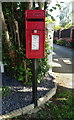
Elizabeth II postbox on Langton Hill, Horncastle
Postbox No. LN9 451.
See Image] for context.
Image: © JThomas
Taken: 17 Jul 2020
0.15 miles
3
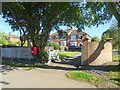
Houses on Langton Hill, Horncastle
Showing position of Postbox No. LN9 451.
See Image] for postbox.
Image: © JThomas
Taken: 17 Jul 2020
0.15 miles
4
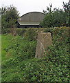
Trig point, hedge and barn
The barn belongs to Langton Hill (farm) and the trig point is known by the OS by the same name; it has flush bracket number S4685.
Image: © Trevor Littlewood
Taken: 7 Oct 2005
0.18 miles
6
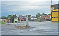
Site of Horncastle station
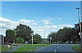
View westward in Station Lane: terminus of the ex-GNR branch from Woodhall Junction, which closed finally 5/4/71, passenger services having ceased from 12/9/54 - a depressing scene?
Image: © Ben Brooksbank
Taken: 26 Jun 1997
0.21 miles