IMAGES TAKEN NEAR TO
Canberra Crescent, MARKET RASEN, LN8 6ER
Introduction
This page details the photographs taken nearby to Canberra Crescent, LN8 6ER by members of the Geograph project.
The Geograph project started in 2005 with the aim of publishing, organising and preserving representative images for every square kilometre of Great Britain, Ireland and the Isle of Man.

There are currently over 7.5m images from over14,400 individuals and you can help contribute to the project by visiting https://www.geograph.org.uk
Image Map
Images are licensed for reuse under creativecommons.org/licenses/by-sa/2.0
Notes
- Clicking on the map will re-center to the selected point.
- The higher the marker number, the further away the image location is from the centre of the postcode.
Image Listing (37 Images Found)
Images are licensed for reuse under creativecommons.org/licenses/by-sa/2.0
Image
Details
Distance
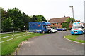
2
Swinhope Road, Brookenby
Heading north east.
Image: © JThomas
Taken: 28 Aug 2015
0.06 miles
3
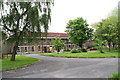
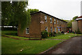
Brookenby: former R.A.F. Binbrook
Now a mixed estate consisting of various grades of housing and industrial units.
There are many green areas, varying in their standard of maintenance, and still many cleared areas and old buildings awaiting redevelopment.
This former shop is for sale or to let.
Image: © Chris
Taken: 5 Jun 2013
0.10 miles
4
Brookenby: former R.A.F. Binbrook
Now a mixed estate consisting of various grades of housing and industrial units.
There are many green areas, varying in their standard of maintenance, and still many cleared areas and old buildings awaiting redevelopment.
These garages are for sale or to let.
This photo shows the Community Centre, with the (disused) shop to the right.
Image: © Chris
Taken: 5 Jun 2013
0.11 miles
5
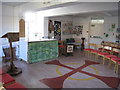
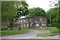
The worship space, the church of St. Michael and All Angels, Brookenby
Image: © Jonathan Thacker
Taken: 22 Oct 2011
0.11 miles
6
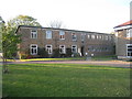
The church of St. Michael and All Angels, Brookenby
An ecumenical church occupying the ground floor of what has become the community building of Brookenby.
Image: © Jonathan Thacker
Taken: 22 Oct 2011
0.11 miles
7
St Michael & All Angels Church, Brookenby
At the former RAF Binbrook.
Image: © Ian S
Taken: 13 May 2018
0.12 miles
8
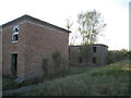
Abandoned buildings, Brookenby
At the former RAF Binbrook the housing has passed to civilian use and many of the hangars are in industrial use but most of the rest has been abandoned.
Image: © Jonathan Thacker
Taken: 22 Oct 2011
0.13 miles
9
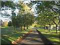
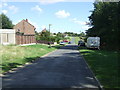
Autumn at Brookenby
Brookenby is what remains of the former RAF Binbrook. Most of the housing is now in civilian use, as are some of the other buildings. Much though is derelict and avenues like this no longer lead anywhere.
Image: © Jonathan Thacker
Taken: 22 Oct 2011
0.13 miles
10
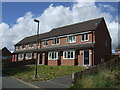
Brookenby: former R.A.F. Binbrook
Now a mixed estate consisting of various grades of housing and industrial units.
There are many green areas, varying in their standard of maintenance, and still many cleared areas and old buildings awaiting redevelopment.
At this (southern) side of the estate are the terraced houses and some semi-detached. A grassed area behind the trees to the left (plus the roadside verge) are home to a pony stud.
Image: © Chris
Taken: 5 Jun 2013
0.13 miles