IMAGES TAKEN NEAR TO
Church Lane, MARKET RASEN, LN8 3XX
Introduction
This page details the photographs taken nearby to Church Lane, LN8 3XX by members of the Geograph project.
The Geograph project started in 2005 with the aim of publishing, organising and preserving representative images for every square kilometre of Great Britain, Ireland and the Isle of Man.

There are currently over 7.5m images from over14,400 individuals and you can help contribute to the project by visiting https://www.geograph.org.uk
Image Map
Images are licensed for reuse under creativecommons.org/licenses/by-sa/2.0
Notes
- Clicking on the map will re-center to the selected point.
- The higher the marker number, the further away the image location is from the centre of the postcode.
Image Listing (111 Images Found)
Images are licensed for reuse under creativecommons.org/licenses/by-sa/2.0
Image
Details
Distance
1
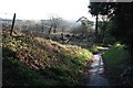
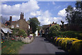
Church Lane
Ancient thoroughfare linking Rasen Road with Front Street
Image: © Richard Croft
Taken: 12 Jan 2008
0.01 miles
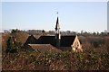
2
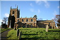
All Saints' church, Tealby, Lincs.
All Saints' church looks down on most of Tealby from the top of the hill. Norman tower with Perpendicular top, Early English and Decorated arcades, the chancel is by James Fowler in 1872.
Image: © Richard Croft
Taken: 20 Feb 2006
0.03 miles
3
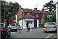
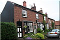
B.Leaning and Sons, Butchers
See Richard Croft's photo: Image
There has been a butcher's shop on this corner of front Street since at least 1842 when it was owned by James Fisher. The present shop was added in about 1865. In 1872 it was owned by Benjamin Leaning, and it is still in the Leaning family.
Richard's photo was taken in 2008, this one 5 years later: it's still there!
Image: © Chris
Taken: 12 Jul 2013
0.04 miles
4
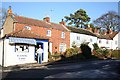
Front Street
There has been a butchers on the corner here since at least 1842 when it was owned by James Fisher. The present shop was added in about 1865 and in 1872 it was owned by Benjamin Leaning - it is still in the Leaning family.
Image: © Richard Croft
Taken: 12 Jan 2008
0.04 miles
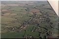
5
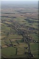
Tealby from Risby Grange: aerial 2017
B1203 Rasen Road.
Image: © Chris
Taken: 5 Jan 2017
0.05 miles
8
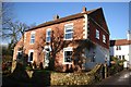
Chapel House
Originally the United Methodist Free Church built in 1857, converted to a house in 1900
Image: © Richard Croft
Taken: 12 Jan 2008
0.06 miles
9
Tealby School
Given to the village in 1856 by Charles Tennyson d'Eyncourt, it was rebuilt after a disastrous fire in the late 19th century, seen here from Church Lane
Image: © Richard Croft
Taken: 12 Jan 2008
0.06 miles
10
River Rase from its source, Tealby and Tealby Thorpe: aerial 2017
The Rase runs down the shot from its various springs starting at Churn Heads springs in the small wood top left (below the linear wood) in Image then across and down alongside Papermill Lane, which runs down Bully Hill, in Image It then passes through Tealby Thorpe (fords) bottom right.
Image: © Chris
Taken: 5 Jan 2017
0.06 miles