IMAGES TAKEN NEAR TO
Otby Lane, MARKET RASEN, LN8 3UT
Introduction
This page details the photographs taken nearby to Otby Lane, LN8 3UT by members of the Geograph project.
The Geograph project started in 2005 with the aim of publishing, organising and preserving representative images for every square kilometre of Great Britain, Ireland and the Isle of Man.

There are currently over 7.5m images from over14,400 individuals and you can help contribute to the project by visiting https://www.geograph.org.uk
Image Map (Loading...)


Getting Data...Please wait
Leaflet Map data © OpenStreetMap
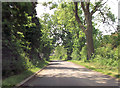
Images are licensed for reuse under creativecommons.org/licenses/by-sa/2.0
Notes
- Clicking on the map will re-center to the selected point.
- The higher the marker number, the further away the image location is from the centre of the postcode.
Image Listing (33 Images Found)
Images are licensed for reuse under creativecommons.org/licenses/by-sa/2.0
Image
Details
Distance
2
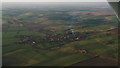
Walesby and the Wolds to the North: aerial 2015
The smoke rises vertically on this warm Easter Sunday afternoon.
The radar facility at Caistor Top is just visible (white ball).
Image: © Chris
Taken: 5 Apr 2015
0.14 miles
3
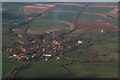
Nil wind in Walesby: aerial 2015
A warm Easter Sunday, and the wind has dropped so that the smoke rises vertically.
The Ramblers' Church to the right of the village.
Image: © Chris
Taken: 5 Apr 2015
0.14 miles
4
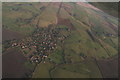
Walesby: aerial 2017
Ramblers' church centre right. Viking Way runs past it and through village.
Image: © Chris
Taken: 5 Jan 2017
0.16 miles
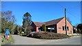
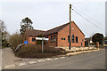
6
Walesby Village Hall
Walesby Village Hall was built in 1988, replacing an ex-army wooden hut. Its position in the centre of the village helps to provide a focal point for the community.
Image: © Neil Theasby
Taken: 18 Apr 2015
0.17 miles
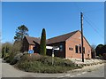
7
Village Hall, Walesby
There is a very small car park behind the village hall with information boards for ramblers.
Image: © David P Howard
Taken: 12 Mar 2016
0.17 miles
8
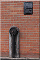
The Old Village Tap, Village Hall, Walesby Hill, Walesby
Automatic shut off tap by J. Blakeborough and Sons Ltd. of Brighouse, Yorkshire. Founded in 1828 and currently listed as dormant it became part of the Hopkinsons Group in the 1970s. The tap was originally sited opposite the old blacksmith's forge it is the last of the gravity fed natural spring outlets that were situated around Walesby. The tap was fed from a spring on the track to All Saints Church via an iron pipe.
Image: © Jo and Steve Turner
Taken: 16 May 2015
0.17 miles
9
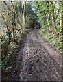
Viking Way descends into Walesby
View WSW down the Viking Way as it enters the village of Walesby.
Image: © David P Howard
Taken: 12 Mar 2016
0.17 miles
10
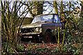
Abandoned in the Hedge
This front half of a Range Rover is abandoned in the hedge off the track up to Walesby church.
Image: © David Wright
Taken: 22 Mar 2006
0.17 miles