IMAGES TAKEN NEAR TO
Tealby, MARKET RASEN, LN8 3UP
Introduction
This page details the photographs taken nearby to LN8 3UP by members of the Geograph project.
The Geograph project started in 2005 with the aim of publishing, organising and preserving representative images for every square kilometre of Great Britain, Ireland and the Isle of Man.

There are currently over 7.5m images from over14,400 individuals and you can help contribute to the project by visiting https://www.geograph.org.uk
Image Map
Images are licensed for reuse under creativecommons.org/licenses/by-sa/2.0
Notes
- Clicking on the map will re-center to the selected point.
- The higher the marker number, the further away the image location is from the centre of the postcode.
Image Listing (6 Images Found)
Images are licensed for reuse under creativecommons.org/licenses/by-sa/2.0
Image
Details
Distance
1
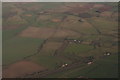
Tealby Moor to Risby: aerial 2017
Across the B1203 Rasen Road and Tealby Moor to Moor Farm and beyond to Risby Grange and Castle Farm in Image
See also Image
Image: © Chris
Taken: 5 Jan 2017
0.06 miles

4
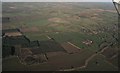
Tealby Moor to Risby: aerial 2017
Across Willingham Woods and the B1203 Rasen Road and Tealby Moor to Moor Farm and beyond to Risby Grange and Castle Farm in Image
See also Image
Image: © Chris
Taken: 5 Jan 2017
0.17 miles
5
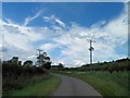
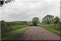
Power lines cross Walesby Road (or Lane)
Image: © Steve Fareham
Taken: 4 Jul 2014
0.24 miles