IMAGES TAKEN NEAR TO
Caistor Road, MARKET RASEN, LN7 6HF
Introduction
This page details the photographs taken nearby to Caistor Road, LN7 6HF by members of the Geograph project.
The Geograph project started in 2005 with the aim of publishing, organising and preserving representative images for every square kilometre of Great Britain, Ireland and the Isle of Man.

There are currently over 7.5m images from over14,400 individuals and you can help contribute to the project by visiting https://www.geograph.org.uk
Image Map (Loading...)


Getting Data...Please wait
Leaflet Map data © OpenStreetMap
Images are licensed for reuse under creativecommons.org/licenses/by-sa/2.0
Notes
- Clicking on the map will re-center to the selected point.
- The higher the marker number, the further away the image location is from the centre of the postcode.
Image Listing (26 Images Found)
Images are licensed for reuse under creativecommons.org/licenses/by-sa/2.0
Image
Details
Distance
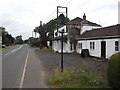
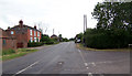
1
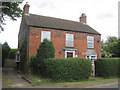
Holly House cottage on the Caistor road
First house west of cross roads
Image: © John Firth
Taken: 5 Jul 2010
0.02 miles
2
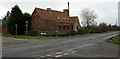
Former Chapel, North Kelsey Moor
Situated on the junction of Station Road and Smithfield Road, North Kelsey Moor. This former chapel of ease (now a house) was built in 1873 by H M Townsend of Peterborough. The chancel and nave can be seen, but the bell turret at the transition between the two is now only a stump.
Image: © Kate Nicol
Taken: 1 Feb 2009
0.05 miles
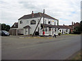
3

Station Road at the Queens Head, North Kelsey Moor
Looking eastward.
Image: © Peter Wood
Taken: 23 Feb 2019
0.07 miles
4
Former chapel of ease, North Kelsey Moor
Built in 1873. The architect was H. M. Townsend. Now a house.
Image: © Jonathan Thacker
Taken: 23 Jun 2011
0.08 miles
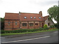
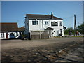
6
The Queen's Head
Another pub bites the dust
Image: © David Brown
Taken: 19 Aug 2020
0.09 miles
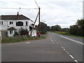
9
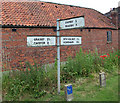
Signpost near North Kelsey Moor
This signpost is on Station Road near the Queen's Head Public House.
Image: © David Wright
Taken: 26 Jun 2006
0.10 miles
10
Junction of Station Road and Owmby Lane
Photo taken looking towards level crossing. Owmby Lane is the turning on the right of the picture. The house is "The Poplars" and falls in TA0701. The level crossing is in TA0601.
Image: © David Wright
Taken: 26 Jun 2006
0.11 miles