IMAGES TAKEN NEAR TO
Limber Road, MARKET RASEN, LN7 6DY
Introduction
This page details the photographs taken nearby to Limber Road, LN7 6DY by members of the Geograph project.
The Geograph project started in 2005 with the aim of publishing, organising and preserving representative images for every square kilometre of Great Britain, Ireland and the Isle of Man.

There are currently over 7.5m images from over14,400 individuals and you can help contribute to the project by visiting https://www.geograph.org.uk
Image Map
Images are licensed for reuse under creativecommons.org/licenses/by-sa/2.0
Notes
- Clicking on the map will re-center to the selected point.
- The higher the marker number, the further away the image location is from the centre of the postcode.
Image Listing (64 Images Found)
Images are licensed for reuse under creativecommons.org/licenses/by-sa/2.0
Image
Details
Distance
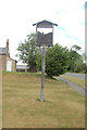
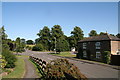
2
Where's the Doctor ?
Even more worrying, where are the daleks ?
Image: © Jonathan Thacker
Taken: 24 Oct 2011
0.02 miles
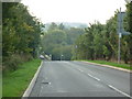
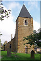
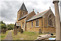
7
Looking down the course of the old A46 in Swallow
The road ahead finishes at the new A46, with the last section now just a byway.
Image: © Chris
Taken: 26 Aug 2013
0.03 miles
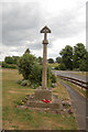
10
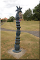
Modern mile stone
On close inspection this appear to be a modern art milestone.
Image: © John Firth
Taken: 5 Jul 2010
0.03 miles